Subject: Exploration and Surveys
Period: 1745 (circa)
Publication:
Color: Black & White
Size:
9.3 x 14.8 inches
23.6 x 37.6 cm
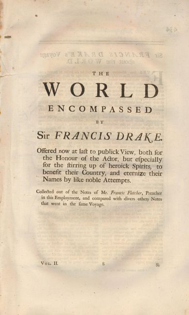
This volume's title continues "Offered Now at Last to Publique View, Both for the Honour of the Actor, but Especially for the Stirring up of heroick Spirits, to Benefit their Country, and eternize their Names by like noble Attempts. Collected out of the Notes of Mr. Francis Fletcher, Preacher in this Employment, and compared with divers other Notes that went in the same Voyage. Vol. II". Disbound volume complete with the title page and pages 434 to 478, four maps. The original uncolored Herman Moll maps are:
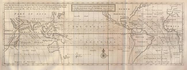
1) A View of ye General & Coasting Trade-Winds, Monsoons, or ye Shifting Trade Winds through ye World…According to the Newest and most Exact Observations, 20.5 x 10.5 ". This chart describes the world between about 50° north and south latitude. This includes from Newfoundland south to just north of Tierra del Fuego. The chart shows nearly blank continents with just country names and little else. Its main focus is an extremely detailed view of sea-borne winds. The legend explains the lines and arrows used to delineate the "General and Coasting Winds" and the "Shifting Trade Winds." The arrows suggest the prevailing direction, but some are annotated with month or season suggesting a periodic wind rather than a year-round, reliable trade wind. With compass rose and fleur-de-lis. Largely based on the work of the English scientist Sir Edmund Halley. ( A)
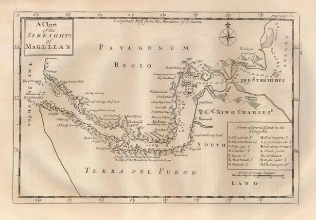
2) A Chart of the Streights of Magellan, 10.5 x 7". Detailed copper engraving of the Strait of Magellan with anchorages and hazards carefully noted. Tierra del Fuego is labeled King Charles's South Land with a notation that it is "A rocky Mountainous Desolate Land the Tops of the Mountains Covered with Snow". Table names and keys fourteen islands in the map. Simple title block and a compass rose. A little water staining at bottom of a very wide margin, well away from map image. Beautiful impression. (A)
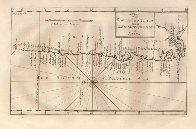
3) A Chart of the South Sea Coast from the Streights of Magellan to Arica, 11.2 x 7". This chart shows good detail along the coast of Chili from Terra Magellanica to Arica, Chili's northernmost city. Compass rose and rhumblinesgrace the South or Pacific Sea.. Bold early impression,some text layout lines are still visible. (A+)
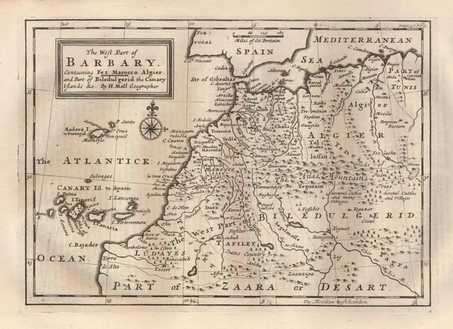
4) The West Part of Barbary. Containing Fez. Marocco, Algier, and Part of Biledulgerid the Canary Islands, 10 x 7". Extends from southern Spain south to Biledulgerid and part of the Zaara or Desart. The settlements of Cadiz, Algier, Teguat, Tasilet, Darca, Moracco, Asgar, and more are located. The Atlas Mountains are named and shown graphically and little trees illustrate Dates Country, oases. Part of Tunis is shown at the right.(A+)
References:
Condition: A
Contents good to very good. Map condition as noted. Volume II is disbound with a later paper cover.