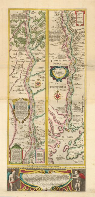
Subject: Ukraine
Period: 1644 (circa)
Publication:
Color: Hand Color
Size:
12.8 x 29.6 inches
32.5 x 75.2 cm
Superb, large map showing the course of the Dnieper River from Cherkasy to the estuary on the Black Sea. The map is in strip style with two vertical maps following the course of the river, each decorated with cartouches and compass roses and including numerous lengthy notations describing the cataracts, cities, salt mines, fortresses, and the historical traditions of the Kozaks. Putti flank a large cartouche at bottom. This map is based on an inset map from the important Radziwill-Makowski map of the Duchy of Lithuania (1613). Two sheets joined, as issued. Dutch text on verso.
References: Ukraine in Old Maps pp. 188-89.
Condition: B+
Sharp impression and fine original color. There is an old paper repair, reinforced on verso with archival tape that closed a fold separation that extends 1" into the map at right. Paper has been added to the bottom margin to better accommodate framing.