Subject: England & Wales
Period: 1729 (published)
Publication: Atlas Minor
Color: Hand Color
Size:
11.8 x 10.8 inches
30 x 27.4 cm
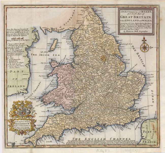
This little map was one of Moll's most popular maps of Britain. First produced in 1717, it was revised and issued a number of times over the next 30 years, appearing in Moll's Atlas Minor and Daniel Defoe's A Tour through the Island of Great Britain (1724) and in Salmon's Modern History (1744-46). It was adapted to show the eclipse of the sun across England (also in 1724), and was copied by Grierson in Dublin. Not all of these uses were approved by Moll as evidenced by the notation below the English Channel, which reads in part "several ignorant Pretenders have started up, and with great Shew and noise frequently advertised their trifling Performances; calling them Cheap, Curious, Usefull and Correct: As to ye first Epithet, they are really Dear at any Price; in ye second place, everybody may see they are wild, confused and Poorly Engraven; as for their Usefulness, they tend only to lead People into Errors; and so far from being Correct, that ye Projection of their Principal Maps is Notoriously False." This is the second state with the addition of an elaborate cartouche dedicated to Frederick, Duke of Cloucester.
References: Shirley (BI) Moll 8.
Condition: B
Issued folded, now flattened with the binding trim at lower right extended to accommodate framing. A few short fold separations have been repaired with tissue on verso. There are a few small stains in the map.