Subject: New York
Period: 1824-1893 (circa)
Publication:
Color:
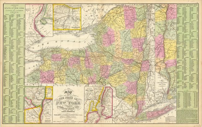
The first map was drawn by S.A. Mitchell and published circa 1852 by Thomas, Cowperthwait & Co., (26.3" x 16") in their New Universal Atlas. This double-page atlas map of New York presents a great amount of information. The map shows the counties, cities, towns, turnpikes, and railroads (proposed, in progress and completed). Five large insets depict the vicinities of Rochester, Albany, Niagara Falls, New York City, and a long inset details the course of the Hudson River from Albany to New York Bay. At both sides are county statistical tables; the major towns with populations from the 1850 census, county area and population, and miscellaneous, for example 184,882 emigrants arrived, 32 steamboats built, 814 students in 4 medical schools. A handsome map that is near fine less light centerfold toning at top (A).
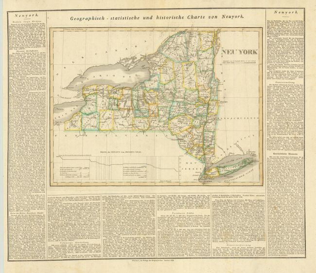
The second map is by Carl Ferdinand Weiland (Weimar, 1824, hand color, 15.8" x 11.8") and is an uncommon German edition of Carey & Lea's map of New York. It shows early towns, roads, rivers, mountains, lakes and other geographical features. Some of the western counties are not yet formed. The road details are quite noteworthy. Carey & Lee's Atlas of North America (1822) adopted the style of the Lavoisne Atlas with descriptive text surrounding the map, rather than on the verso or other sheets. The atlas was a commercial success. In addition to the second and third editions published in Philadelphia, a French edition was published by Buchon in 1825, and a German edition was published by Weiland in 1824. For the German edition, the maps were re-engraved by the Weimar Geographischen Institut. The German edition is by far the rarest and the maps are among the earliest state maps printed outside the United States. Text on three sides, overall sheet dimensions are 22 x 18.5". Original outline color with some light damp stains in the margins and text and minor soil in the map (B+).
References:
Condition:
See individual descriptions.