Subject: World and Celestial
Period: 1662 (circa)
Publication:
Color: Hand Color
Size:
29.5 x 17 inches
74.9 x 43.2 cm
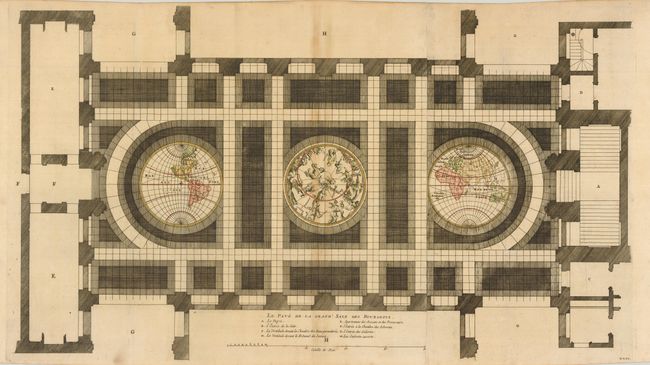
This unique sheet depicts three maps that were laid in the marble floor of Amsterdam Town Hall. At center is a celestial map of the northern sky with the Western and Eastern Hemispheres on either side. The maps are rudimentary with simple continental outlines and river systems shown. California is shown as an island as would be expected for a map of this period. In the Eastern Hemisphere is one of the earliest depictions of Abel Tasman's discovery of Tasmania. Tasman made those discoveries in 1642-43. However, it was several years before the results of the exploratory voyages were made public due to the secretive nature of the East India Company and their desire to maintain its monopoly on trade in the region. This map appeared in the French edition of Jacob van Campen's work detailing the Civic Hall of Amsterdam on thirty copper plates.
References:
Condition: B+
A fine, dark impression with faint toning along the centerfold and a tiny edge tear at bottom, not affection the image.