Subject: Massachusetts, Martha's Vineyard
Period: 1892 (dated)
Publication:
Color: Hand Color
Size:
37 x 25 inches
94 x 63.5 cm
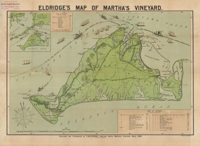
This rare tourist map, copyright and published by G.W. Eldridge, Vineyard Haven, Cape Cod, Mass., is compliments of "Martha's Vineyard Association" according to stamp in upper left margin. The strongly colored duo-tinted lithographic chart shows the entire island in fine detail at a scale of 2/3 mile per inch. Coastal features include Vineyard Haven Harbor, Cape Poge, Katama Bay, Menemsha Bight, Gay Head Cliffs, etc. Inland, the roads, villages, parks and other attractions are named and relate to the Table of Distances, 32 distances from Vineyard Haven, Edgartown and Cottage City to various points of interest on the island. Large direction star with sixty-four points and fleur-de-lys. At upper left is a large inset "Plan Showing Relative Position of Martha's Vineyard with Mainland" and a second Table of Distances to towns in the surrounding area. The shipping lanes for the Maine Steamship Company, Old Colony Line, and the West Chop Steamship Company are delineated and sailboats, clipper ships and two steamships illustrate. Lithography by Forbes, Co., Boston. A rare promotional map intended for the tourist trade.
References:
Condition: B
The map has been mounted on archival tissue. One fold with abrasion and loss in mostly blank sea, a little darkening near lower distance table. The original ink stamp in upper left margin does not encroach into map.