Subject: California
Period: 1850 (dated)
Publication: Sen. Ex. Doc. 47, Part I, II, 31st Cong., 1st Sess.
Color: Black & White
Size:
5.8 x 9 inches
14.7 x 22.9 cm
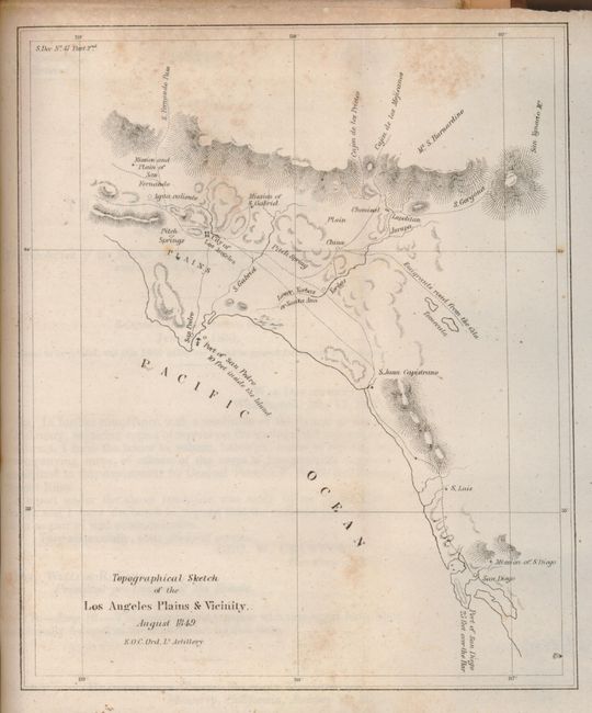
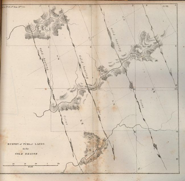
Commonly referred to as the "Geology of California" this complete report contains the Tyson, Derby, Williamson, and Ord maps, making it very scarce. An American geologist, Philip Tyson traveled in California during the summer and early fall of 1849 and based his report on personal observations of the gold regions and deposits. Wheat notes that his report is "probably the earliest work of true scientific research to emerge from the Gold Rush. Its author was a gifted scientist whose pioneering effort was of considerable value." In addition to the gold fields, his geological examination covered portions of the Sierra Nevada, Coast Range, Sacramento Valley, and the mines of the quicksilver region. He described his visits to the "canvass" city of Sacramento, Mormon Island, Coloma, Jackson, and Sutter's Creek, and the general region of the Cosumnes and Mokelumne Rivers. Tyson's report (127 pages plus Part II comprised of 37 pages of related correspondence) is accompanied by three large maps and ten smaller folding plates and map. These consist mainly of geological cross sections (some as large as 6 x 36 inches) extending from San Francisco to Sierra Nevada, Gold Region to Calaveras, Gold Region from Yuba to Coloma, etc., and some small maps, including the Los Angeles Plains and Vicinity dated August 1849, by E. O. C. Ord. Bound in modern brown and green marbled boards with leather spine, and black spine label with gilt lettering. The larger folding maps are:
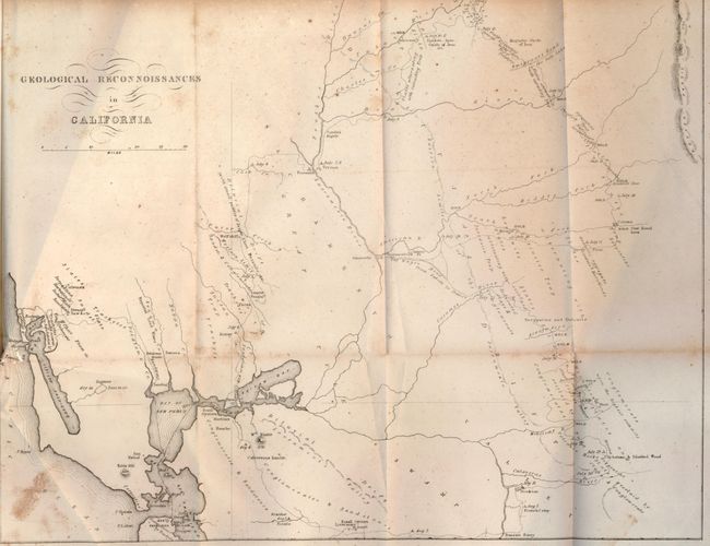
(1) Geological Reconnoissances in California, (14.8 x 11.6 inches) details the month-long expedition from San Francisco to Benicia and on to the Yuba diggings, hence through the Gold Regions, the Calaveras River and returning via Livermore's Ranch to Martinez. A second route is shown to Bodega Bay and the north coast. Coloma is noted as the place gold was first found. Information includes the dates on which various localities were visited, the geological conditions, and the points where gold was being dug. Sacramento, Stockton, the Wagon Road from Suter's to Dater's, and the Emigrant's Road to the Salt Lake are located. In his geological map catalogue, Marcou lists this map as the first geological map prepared for a portion of California.
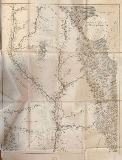
(2) The Sacramento Valley from the American River to Butte Creek… by Lieut. Derby, 1849, (12 3/4 x 23 3/4 inches). This is a map of major importance to the California Gold Rush. On a scale of 4-1/2 miles to the inch, it provides a detailed view of the region with numerous small towns, ranches, Diggings, trails and roads. Sacramento is established just south of the American River, with numerous gold diggings named, including Mormon and Dry. Interesting notations concerning grazing, road conditions, soil fertility, etc. Short binding trim tear.
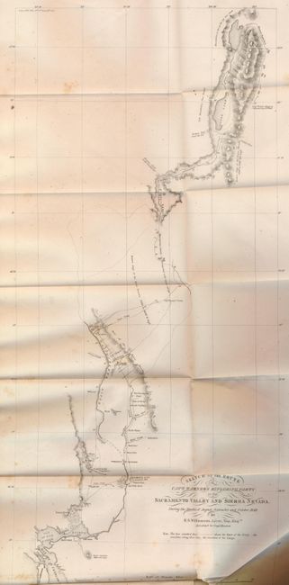
(3) Sketch of the Route of Capt. Warner's Exploring Party in the Sacramento Valley and Sierra Nevada, by R. S. Williamson, 1849, (12.8 x 23.5 inches). This map details the route of Warner's party from Benicia near San Francisco to Sacramento City, up the Sacramento River and into the High Sierras in the vicinity of Goose Lake. In the northern Sierras are "Mountains as far as the eye can reach." The Oregon Trail from the U.S. and the Oregon Trail from California is an early reference to the Oregon Trail, normally called the Immigrant Route at this time. Trails, farms, mines etc. are identified along the route. The map provides the first information of the mountainous region northeast of the Central Valley, and is a source document on the Lassen Cutoff. Capt. Warner was tasked with finding a suitable railroad route up the Sacramento Valley. Though he discovered a suitable pass, his party was ambushed by Indians and he was killed (the location of his death is marked on the map). His notes and a sketch map were rescued, and from these Lt. Williamson produced this map and a report, the first published documents to show any detail of the country.
This scarce, complete and highly desirable report related to California and the Gold Rush.
References: Howes T455; Marcou #670; Wheat (Gold) #179; Wheat (Gold) #149.
Condition: B
Complete with all maps and plates as issued. Very little evidence of wear. With scattered foxing, as usual, to pages and plates, but otherwise unmarked and clean. Binding is tight and attractive, fine condition.