Subject: Central United States
Period: 1858 (dated)
Publication: Sen. Ex. Doc. No. 36, Ho. Ex. Doc No. 108, 2nd Session. 35th Congress
Color: Black & White
Size:
32 x 18.5 inches
81.3 x 47 cm
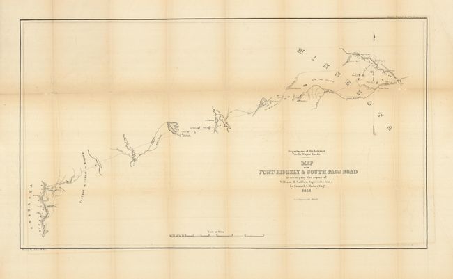
This highly detailed map delineates the 255-mile long road between Fort Ridgely westward to the Missouri River around today's Chamberlain, South Dakota. The route heads west, initially following the Cotton Wood River. It passes by Lynd's Trading Post, Old Indian Fortifications, the Plateau du Coteau du Misouri, and crosses Red Wood Creek, Big Sioux River, Wolf Branch of Morse's Creek, Dacota or James River, and Wessington Springs. It locates the Lower Sioux Agency, New Ulm, Tuttles Winter Quarters with a nearby Indian Village, and Agency Mills. The completion of the road was hampered by prairie fires and by the Yankton Sioux demanding compensation. Drawn by John R. Key for Samuel A. Medary, Engr. to accompany the report of William H. Nobels, Superintendent. Lithographed by the Philadelphia firm of T.S. Wagner. On a scale of 10 miles per inch. A seldom seen map.
References: Wheat #987.
Condition: B+
A little fold toning and some fold intersections reinforced on verso with archival tape.