Subject: Colonial New England
Period: 1776 (dated)
Publication:
Color: Hand Color
Size:
38.3 x 39.5 inches
97.3 x 100.3 cm
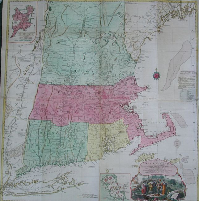
The title continues "Divided into Counties and Townships: The whole composed from Actual Surveys and its Situation adjusted by Astronomical Observations. Published by Tobias Conrad Lotter, in Augsburg." This is Lotter's German edition of one of the most detailed, accurate, and certainly most visually impressive, maps of New England. The map was original published by Thomas Jefferys in 1755 (McCorkle #755-19) and is believed to have been compiled by Braddock Mead, alias John Green. Lotter's edition does not give attribution to Jefferys’ map, but is virtually identical. This pre-Revolutionary War map provides remarkable detail in the region from Long Island in the south up to 44°30’ to include Brunswick and George Fort. The map includes two fine insets: "A Plan of the Town of Boston" and "A Plan of Boston Harbor" and a superb vignette of the Pilgrims' 1620 landing lies beneath the title cartouche. Engraved on four folded separate sheets, here joined.
References: McCorkle #776-16; Sellers & Van Ee #801.
Condition: A
A beautiful example with original full color and with a very dark, early impression. A strip of paper laid in along binding trim outside of neatline, and a short split at right margin along paper join. Issued folding now flattened with some lazy fold lines.