Subject: United States
Period: 1883-95 (dated)
Publication: HR. Ex. 1, 49th Cong., 1st Sess.
Color: Black & White
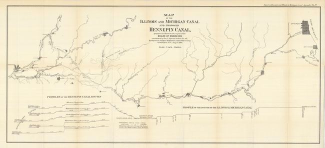
1. Map of the Illinois and Michigan Canal and Proposed Hennipen Canal. 1886 (40.5 x 18"), Report on Hennepin and Illinois & Michigan Canal, Appendix No. 12. Map delineates the proposed canal from Chicago to Davenport on the Mississippi River. Cities along the route include Joliet, Morris, Ottawa, La Salle, Hennepin, Wyanet, Geneseo, and more. The Kankakee, Fox, Little Vermillion, Green and Rock Rivers and numerous creeks are shown. Along the bottom is a detailed elevation for the projected canal. One very light offsetting line across the map, otherwise fine.
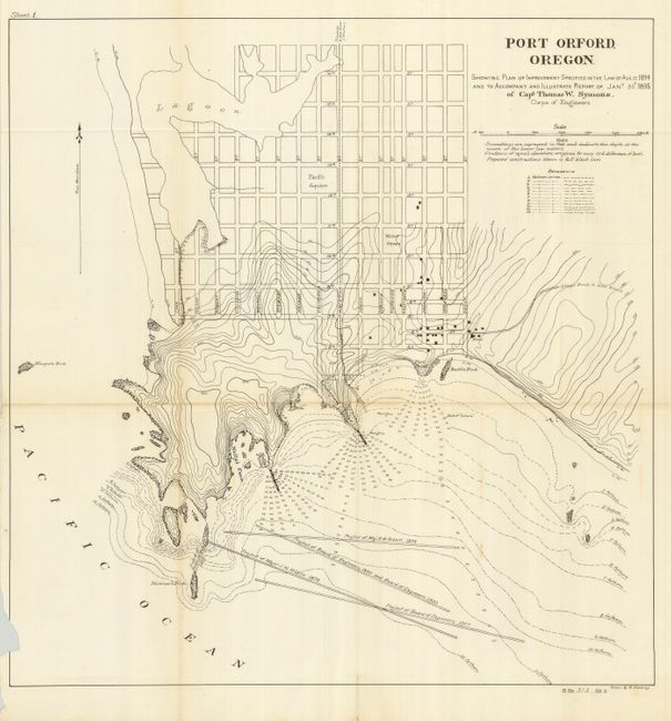
2 & 3. Port Orford, Oregon. 1895. Vicinity (12.5 x 13.8") and street plan (18 x 18"), H. Ex. 313, 53rd Congress, 3rd Session. The street map shows a nice plan of Port Orford, locates Battle Rock, Graveyard Point, Nelly's Point, the Stage Road to Gold Beach, and more. With a small missing section into neatline on binding trim side. Light toning on the vicinity map.
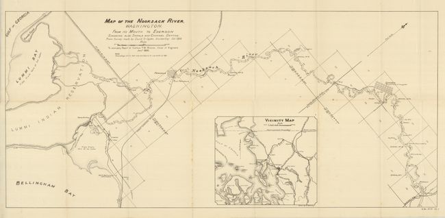
4. Map of the Nooksack River, Washington. 1895 (30.5 x 14"), Report of Capt. T.W. Symons. Ferndale and Lynden are shown in street grid. Large inset is a Vicinity Map which extends to show Orcas Island, Fairhaven, local railroads, and more.
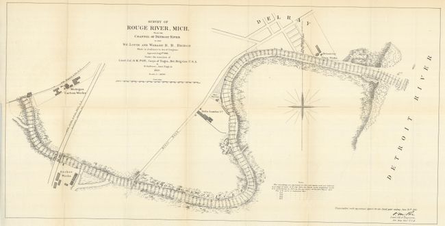
5. Rouge River, Mich. 1887. (33 x 16.5"). Map includes a partial street plan of Delray, locates the Detroit City Glass Works, Glue Factory, Delta Lumber Co., Anchor Works, Michigan Carbon Works, and Geo. Brady's Dock. Signed in the plate by Lieut. Col. O.M. Poe, Corps of Engrs., Brt. Brig. Gen. U.S.A.
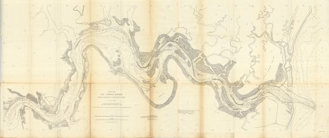
6 & 7. St. John's River, Florida. 1885 (29 x 22") and 1894 (51.5 x 20.5"). The 1885 chart locates Atlantic House, Robinson Cottage, the New Light, Johnson's Wharf, and the new jetties. Signed in the plate by Captain Wm. T. Russell. The 1894 chart is an extremely detailed look at the course of the river from its mouth upstream to Jacksonville, here shown in a grid pattern. The latter has centerfold toning and three fold intersection splits.
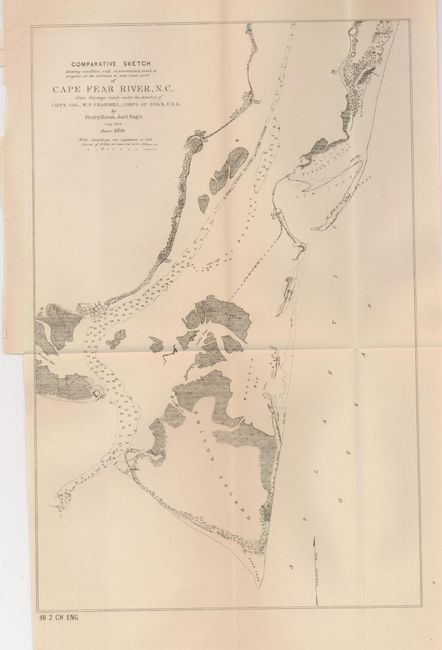
8. Cape Fear River, N.C. 1884 (8.8 x 13.5") Good detail of the coast and islands, map locates Smith's Island, the Big Marsh, Federal Point and more, and includes a simple grid plan for Smithville.
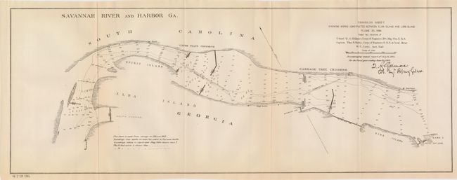
9, 10 & 11. Savannah River and Harbor Ga. 1884 Progress Sheet (22.3 x 8.3"), Sheet I, (30 x 17") and II, (34 x 16") 1885. Each is signed in the plate by the Colonel of Engineers, Q.A. Gillmore. The progress sheet shows the area between Elba and Long Islands. Sheet I locates Fig Island Getty, Fort Oglethorpe, the three Barnwell islands, Spirit Island, a submerged dam (1881) and more. Sheet II continues to show construction details from Elba Island to Cockspur Island. Locates the Cabbage Tree Crossing, Bird Island, Fort Pulanski, the Quarantine Station and an Oyster Bed.
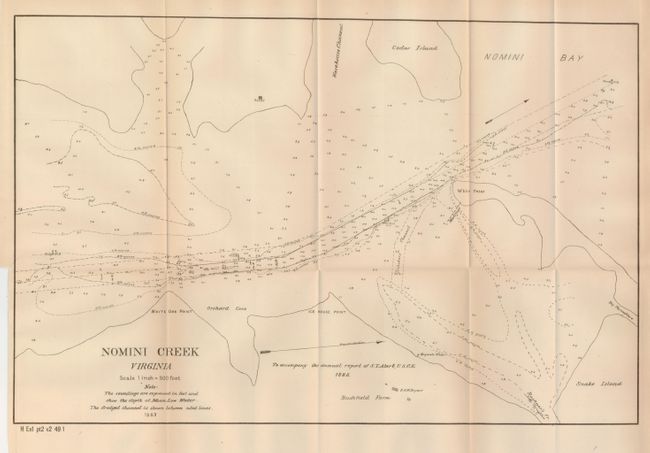
12. Nomini Creek Virginia 1883 (18.8 x 12"). Information includes Cedar Island, the home of the Reed's, the Bushfield Farm and home of R.H.W. Bryant, Cedar Island, Snake Island and more.
13. Sandusky Bay 1887. (17 x 20.5). Shows limited street grid and Sandusky's waterfront with wharfs. Extends to Johnson's Island and Cedar Point. Signed in the plate by the Major of Engr., L. Cooper Overman.
References:
Condition: A
The maps are each folding, as issued. Each is near flawless and vary very good to fine except as mentioned in item description.