Subject: United States
Period: 1862 (circa)
Publication: Black's General Atlas
Color: Hand Color
Size:
21.8 x 16.3 inches
55.4 x 41.4 cm
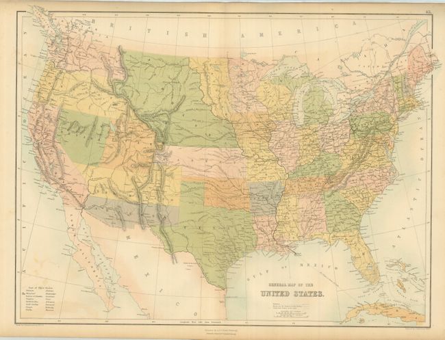
This Scottish-produced map shows excellent detail throughout the U.S. In the west the early territorial configurations include some of the most interesting seen on any map. Washington and Oregon extend to the Continental Divide, where they meet the huge Nebraska Territory which reaches to the Canadian border and eastward to the newly formed Dacotah at the Missouri River. Dakota is a small area that lies between Nebraska and Minnesota, bounded between the Missouri River on the west and the Sioux and Red Rivers on the east. The oversized Kansas Territory stretches west to the Rocky Mountains near today's Denver. The Confederate Territory of Arizona lies beneath New Mexico Territory, extending from Texas to California. Utah is a large territory that includes much of Colorado, but does not name Colona. The border between Utah and Nevada is the rare configuration with the line deviating from vertical near Sevier Lake and following the Virgin River south-southwestward. Oklahoma is entirely Indian Territory. Interesting map is filled with railroads, towns and villages, forts, Indian Lands, and more, and using an early technique, " Printed in Colours by Fr. Schenck, Edinburgh."
References:
Condition: B+
The map is fine less a few spots at lower left and one area at upper right. Beautiful color and full margins.