Subject: United States
Period: 1833-1909 (dated)
Publication:
Color:
Historical set of folding maps which together detail the evolution of Indian Reservations in the United States over a period of 77 years.
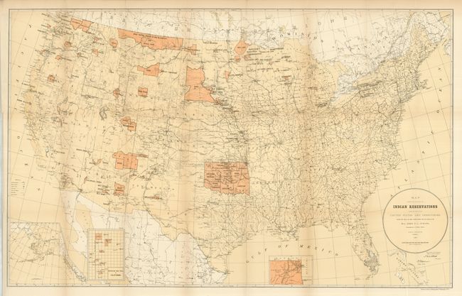
1) Map Showing the Locations of the Indian Reservations within the Limits of the United States and Territories. Compiled from Official and Other Authentic Sources, under the Direction of the Hon. John D.C. Atkins, Commissioner of Indian Affairs., Washington D.C., 1885. This large map shows reservations across the United States and locates towns, railroads, military stations and Indian agencies. Some color. (33.5 x 21"). Folding as issued on thick paper with full margins and very nice impression. Some short fold intersection splits, one is longer. Also a binding side trim, closed on verso. (B)
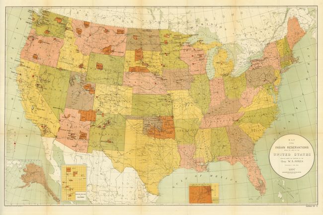
2) Map Showing Indian Reservations within the Limits of the United States Compiled under the Direction of the Hon. W.A. Jones. Commissioner of Indian Affairs., Norris Peters Co., Washington D.C., 1897. This colorful map shows reservations across the United States and locates towns, railroads, military stations, schools, and Indian agencies. Three insets provide additional detail of reservations in Indian Territory, Mission Ind. Res. of California, and the Territory of Alaska. Full color. (33 x 21"). Fold intersection splits, one longer. (B)
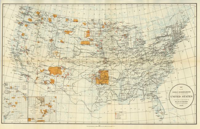
3) Map Showing Indian Reservations within the Limits of the United States Compiled under the Direction of the Hon. R.G. Valentine. Commissioner of Indian Affairs., Washington D.C., 1909, printed color. Insets of Mission Ind. Res. in California, the Indian Pueblo Grants in New Mexico and northeastern Oklahoma. (24.8 x 15.5"). Folding as issued with full margins, crisp impression and bright color. Tear along upper fold enters map 1", closed on verso with tape repair, otherwise very good. (B)
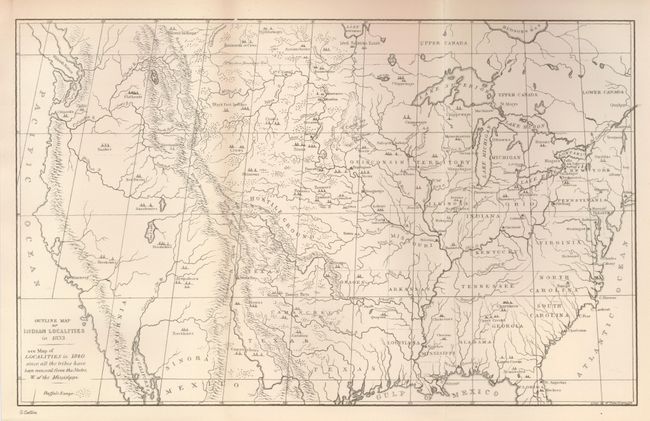
4) Outline Map of the Indian Localities in 1833. George Catlin, uncolored (13 x 8"). This great map was published in an edition of Catlin's Indian Gallery. The map names scores of Indian villages, all located by tipi symbols. The map extends well into Canada, locating numerous Canadian tribes. There is good detail of watershed and the known mountain ranges. The West is mostly blank and contains erroneous information in the Great Basin region derived from Fremont's map, including an east-west flowing river. Texas is shown with its northern border extending well into the Rocky Mountains, but it is indistinct at its upper reaches. Of special interest is the depiction of the Buffalo Range that stretches throughout the entire plains region. Folding as issued, fine (A+).
References:
Condition:
See individual descriptions.