Subject: Eastern Canada & United States
Period: 1784 (dated)
Publication:
Color: Hand Color
Size:
30 x 21.325 inches
76.2 x 54.2 cm
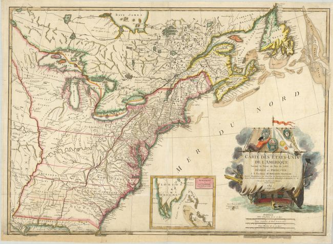
This is the first French map of the official, newly created United States of America following the peace treaty of September 1783. It is also one of the most beautiful maps of the period. It is based largely on John Mitchell's landmark map of 1755. The map extends to cover most of eastern Canada with emphasis on the great fishing banks off Newfoundland. The western boundary of the United States follows the Mississippi River and the region west of the Allegany Mountains is shown to be occupied primarily by numerous Indian nations with a few scattered forts. A large inset depicts southern Florida and the Bahamas. The map is dedicated to Benjamin Franklin, ambassador to France, and the principal U.S. representative in the peace negotiations. The stunning cartouche contains the title and dedication on the unfurled sail of a ship sailing in the Atlantic. The Great Seal of the United States, which incorporates the bald eagle as a symbol of the nation, was formally approved by Congress in 1782 just before Ben Franklin left for Paris to sign the official treaty between the U.S., Britain and France. The seal of the Society of the Cincinnati, which also incorporates the bald eagle symbol, was designed by L'Enfant and approved in 1783. The Lattre map is the first map to display both of these seals, and the first time that a foreign document endorsed either seal. This map would be an important addition to an American map collection and is rarely seen on the market.
References: Ristow, p. 63.
Condition: C+
Damage along the bottom affecting the border with some paper loss with paper added along bottom including part of the neatline in facsimile. The repair is stable, although this fine map is deserving of professional conservation and the estimate reflects the costs of that conservation.