Subject: North America, Texas
Period: 1843-44 (dated)
Publication:
Color: Hand Color
The United States and Great Britain established in 1818 joint claim over the Oregon Territory - the region north of Spanish controlled Upper California up to the southern boundary of Russia's Alaska Territory at North latitude 54°40'. By the late 1830's this arrangement was beginning to fall apart.
In the 1840's the expansionist Democrats, including their 1844 presidential candidate, James Polk, claimed the entire region for the United States. Their expansionist desires were expressed by Polk's famous campaign slogan, "Fifty-four Forty or Fight!" The slogan also became a rally cry for Americans desiring to settle the territory. Following Polk's election, the dispute was resolved by the 1846 Treaty of Oregon, which struck a compromise that fixed the U.S./Canadian boundary at 49º North.
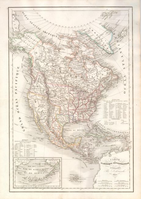
The first is an uncommon edition of this map of the continent with the Independent Republic of Texas and early western territorial borders in the United States. Delamarche, Charles Francois Delamarche, Paris, 1844, 11.3" x 17". The District Oregon ou Colombie extends into present-day British Columbia and is bounded by the Rocky Mountains. Missouri Territory takes in the entire region between Oregon and the Mississippi except for the young states of Missouri, Arkansas and Louisiana. The mapping in the Great Basin shows pre-Fremont information with numerous rivers including two branches of the Buenaventura running straight through on its way to the Pacific Ocean. The map is filled with the locations of many Indian Districts and Tribes. The Aleutian Islands are shown in an inset on the same scale as the main map. A table at right lists 26 states, plus the territories of the United States, and at left, another table lists 20 states for Mexico. Near fine example with just a little foxing or soiling in margins. The U.S. state boundaries have additional color added as dashes, a technique we've not previously seen, but the color appears as original (A).
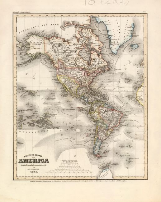
The second map is by Carl Christian Franz Radefeld, 1843, Meyer's-Handatlas, Hildburghausen, 11.8" x 14.5". It is a very detailed map of the Western Hemisphere prominently showing the ocean currents. The precisely engraved chart carries an amazing amount of detail: major towns, countries individually colored, topography and watershed are well developed. Texas should be shown as independent but is included in Mexico which includes all of the Southwest and Utah. The United States is shown with claims into present-day British Columbia supporting America's Fifty-Four Forty or Fight theme. The 'Antarktisches' continent is shown with several named islands and Trinity Land in the north. Excellent detail of the islands of the South Pacific. With imprint for Geographischen Graviranstalt des Bibliograph Instituts zu Hindugghausen at bottom. Very dark, fine impression and wide margins (A+).
References:
Condition:
See individual descriptions.