Subject: North America
Period: 1825 (published)
Publication: Atlas Geographique, Statistique, Historique et Chronologique…
Color: Hand Color
Size:
14.3 x 14 inches
36.3 x 35.6 cm
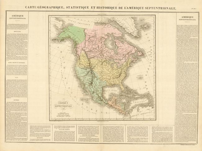
The United States and Great Britain established in 1818 joint claim over the Oregon Territory - the region north of Spanish controlled Upper California up to the southern boundary of Russia's Alaska Territory at North latitude 54°40'. By the late 1830's this arrangement was beginning to fall apart.
In the 1840's the expansionist Democrats, including their 1844 presidential candidate, James Polk, claimed the entire region for the United States. Their expansionist desires were expressed by Polk's famous campaign slogan, "Fifty-four Forty or Fight!" The slogan also became a rally cry for Americans desiring to settle the territory. Following Polk's election, the dispute was resolved by the 1846 Treaty of Oregon, which struck a compromise that fixed the U.S./Canadian boundary at 49º North.
This is the French edition of Carey & Lea's map of North America. On a full sheet (26.8 x 21") with French text panels at sides and bottom describing the history, geography, Indians and more. Blank verso. The map shows Mexico in control of the Southwest. The United States extends to the Pacific Ocean and reaches far north into Canada showing the boundary which becomes the Fifty-Four Forty or Fight dispute between England and the U.S. Alaska is Amerique Russe with good detail and place names along the coastal region, but a fully blank interior. Many Indian regions are noted. In Texas (unnamed) only a few places are named; S. Antonio, Rancho, Matagorda, and San Saba. A bizarre mountain range diagonally crosses the Great Basin from Utah and nearly reaches the coast in the direction of San Clemente. The R. del Carmelo ou St. Phelipe, originating in L. Teguanyo ou Salo, freely runs through the Great Basin to its mouth at Monterrey. Mexico is divided into states. Likewise the states and territories of the United States are delineated with Arkansas and three unnamed areas to the north. Santa Fe, Taos and Albuquerque are located. Engraved by B. de Beaupre.
References:
Condition: A
Good impression and original hand coloring on a full sheet with original margins. A trace of offsetting in wide blank area between text and the map.