Subject: North America
Period: 1783 (dated)
Publication:
Color: Hand Color
Size:
25 x 18 inches
63.5 x 45.7 cm
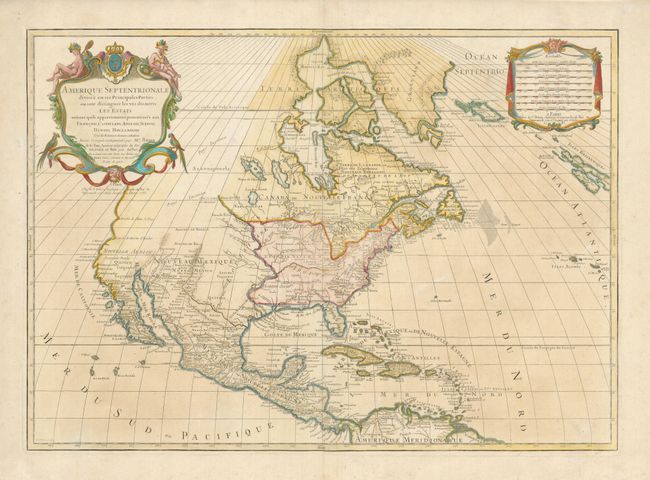
A large map of North America showing the new United States taking in the region east of the Mississippi River, save for the Gulf Coast and Florida, which are Spanish possessions. The Mississippi River is too far to the west with its mouth in present-day Texas. The Northwest is labeled Pays Inconnu and the coast is mostly a straight line above C. Blanco with small indents at the Entrée de Martin d'Aguilar and Entrée Juan de Fuca. This is a very early map naming the United States, here hastily added offshore. There are scores of place names, forts and Indian tribes including the large area denoted as "Les Six Nations" that takes in the vast region between the Great Lakes and the Ohio River. Lovely title cartouche with Native Americans and tropical birds at upper left, balanced by the distance scale cartouche on right.
This attractive map was very popular and had a long publication history. The first state, 1689-1713, showed California clearly as an island with an indented northern coastline and Sanson's characteristic islands in the Mare Vermejo. The second state, 1719, updated much of the cartography but left the question of California's insularity open by eliminating the land to its north and west, but leaving a gap at the head of the Mare Vermejo. This is the third state, 1783, with California definitively shown as a peninsula. It was published by Desnos, with his imprint added below the title cartouche. Brion de la Tour is noted in the cartouche to have corrected and augmented the cartography. However, it is interesting that the course of the Mississippi River remains unchanged and the large mythical lake in Georgia is retained. The map is very similar to other Sanson/Jaillot maps of North America, and with a nearly identically title. This map is dedicated to the King, rather than the Dauphin and it is slightly smaller.
References: McCorkle #695.4; McLaughlin #101.
Condition: B+
There are a couple of minor abrasions in the map and some uneven toning.