Subject: East Indies - Indonesia
Period: 1598 (circa)
Publication: Petits Voyages, Part II
Color: Hand Color
Size:
17 x 14.8 inches
43.2 x 37.6 cm
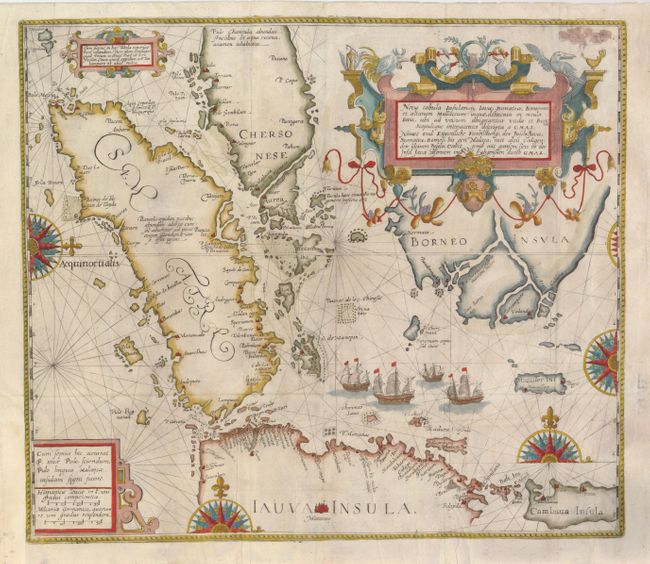
This is a very important landmark map in the mapping of South East Asia. It is an adaptation of Willem Lodewijcksz' map from the first Dutch voyage to the East Indies by Cornelis de Houtman in 1596. Lodewijcksz' map had been suppressed by the Dutch merchants, and while a few copies were separately issued by Claesz for use at sea, only two examples are extant today. Therefore, De Bry's version is the earliest printed detailed map of the region available to collectors.
The stunning map focuses exclusively on southern Malaya and Borneo, Sumatra, Java, Sumbawa and many of the smaller Indonesian islands. The map records extraordinary detail along the western and northern coast of Java and a plethora of small islands in the Sunda Strait, which was the entrance channel used by the Dutch to avoid the Straits of Malacca that was controlled by the Portuguese. The map is presented in the sea chart style with only coastal place names except for Mataram, a city in the center of Java that is prominently depicted as its commercial capital. The island of Macasser is shown here as a separate island from Sulawesi with Bogis referring to the renowned Buginese seafarers and traders of the region. The Malay Peninsula is labeled Chersonese Aurea, and the southern tip is bisected by a large waterway. Singapore (C de cinca pura) is shown on the tip of Malaya and the islands south and east of the peninsula appear in better detail than on earlier maps. Baixos de los Chinese (rocks of the Chinese) are marked in the waters between Sumatra and Borneo, referring to low islands that were frequented by Chinese traders. An error in the latitude markings places the north coast of Bali at about 7° south latitude, instead of the closer to correct 8.5° that was on Lodewijcksz' map and log from the voyage. Bali itself is depicted for the first time in recognizable form. The map is beautifully engraved in De Bry's extravagant style with huge compass roses, three elaborate cartouches, and a fleet of sailing ships.
References: Garratt (TMC-9) p. 9-10, #P4; Suarez (SEA) p.181-82, fig.95.
Condition: A
Issued folding, now flattened, with some tissue reinforced fold intersections. The binding trim at lower left has been extended to accommodate framing.