Subject: Alaska
Period: 1904-17 (dated)
Publication:
Color: Printed Color
A nice lot of maps related to the burgeoning gold and other mining activities in Alaska.
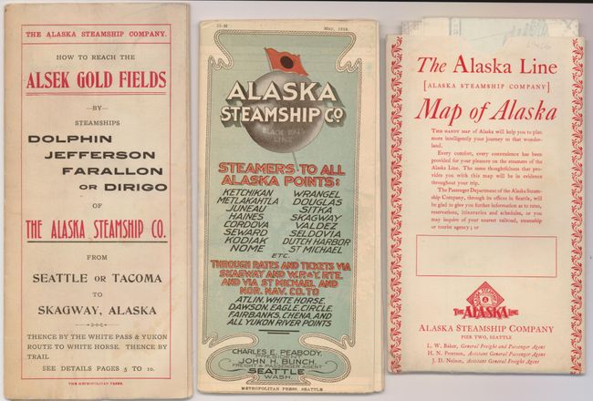
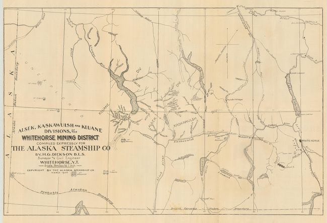
1) Alsek, Kaskawulsh and Kluane Divisions of the White Horse Mining District…, The Alaska Steamship Co., 1904, (24.3 x 16.3). Map folds into printed color self-wrappers (4.2 x 9") entitled "How to Reach the Alsek Gold Fields" with extensive promotional text on verso. Locates the Hutshi Village, White Horse, the British Yukon Railway and more. The mining areas are well shown with all creeks and lakes noted. Area to the west is blank and simply labeled "Unexplored." Good image of the steamship Dolphin on verso with descriptions for the Jefferson, Dirigo, and Farallon. There are some corner fold splits, paper is clean with a fine impression. (B+)
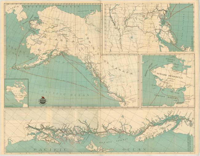
2) Alaska Steamship Co. Map of Alaska, Metropolitan Press, Seattle, 1910, (30.3 x 24.8"). Three large and one small inset maps, with text, photos, timetables on verso. The large map of Alaska and western Canada shows the steamer routes in red overprinting; the traditional gold field routes plus routes to Seward, Homer, Iliamna, Kodiak, Chignik, Unga, Dutch Harbor, Nome and more. With three large insets: detail of the Seward Peninsula; "Map of the Southeastern Alaska Route" shows the inland passageway; and the Kenai Peninsula and south central Alaska which details Copper Center and extends to the Yukon River. Short railroads originate in Seward and Cordova. Several images on the verso include the steamship Dolphin, salmon, and an uncommon image of the village of Wrangel. Folds into self wrappers, (4.3 x 8.4") titled "Steamers to all Alaska Points: Ketchikan…" listing sixteen ports. A soft fold and a few small fold intersection splits, otherwise fine. (A)
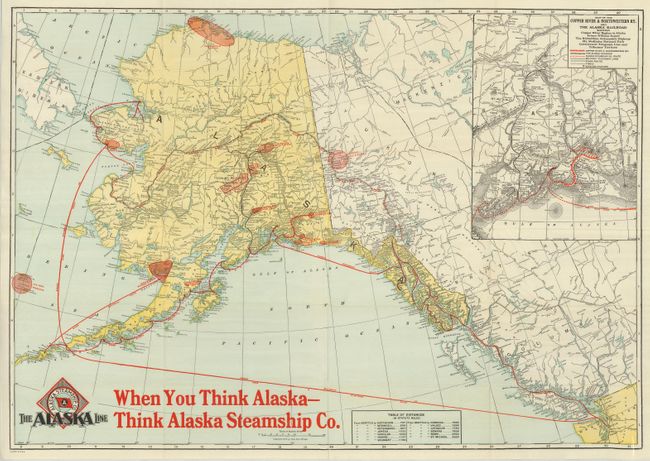
3) [The Alaska Line Map of Alaska], Poole Bros., Chicago, 1917, (30.3 x 21.5"). This large map is filled with information. It locates the Kennecott Copper Mines (in Copper Basin), Matanuska Coal Fields, Klondike Gold Placers, Nenana Coal Fields, Fairbanks Gold Placers, Nome Gold Placers, Point Barrow Oil Field (which extends to today's Prudhoe Bay), the Katalla Oil Field, Mt. McKinley National Park, and more. The routes of the Alaska Steamship Company and the rail routes from Seward to Eldorado via Fairbanks are shown. Of the three, this is the only map to name Anchorage. A large inset map of railroads into the territory. Map folds into original printed envelope, (4.5 x 7.6") with the same title. Fine (A+)
References:
Condition:
See individual descriptions.