Subject: Exploration and Surveys, Western United States
Period: 1905 (published)
Publication:
Color: Printed Color
Size:
6.5 x 9 inches
16.5 x 22.9 cm
A fine copy of this report which contains General Land Office reports and accompanying maps of Alaska, Arizona, Hawaii, Oklahoma, New Mexico and Porto Rico. Hardbound, 907 pp., six foldout maps. The maps are:
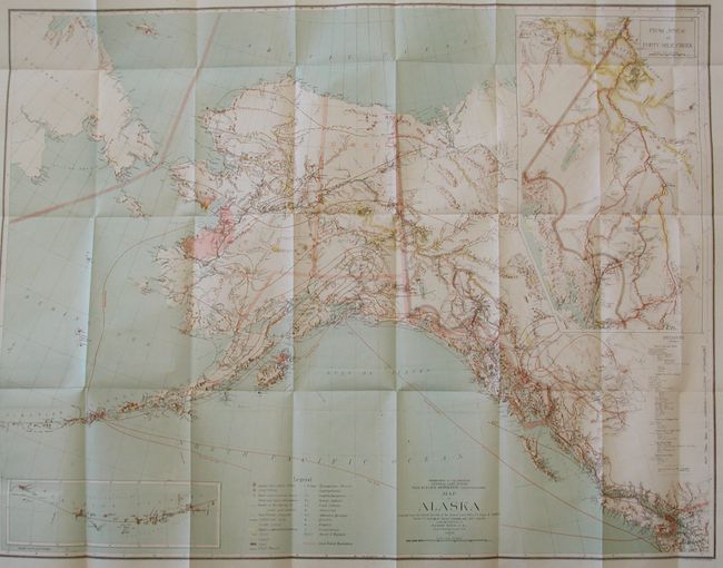
1. Map of Alaska, 1898, (32.3" x 25"). This is a large and colorful map of Alaska Territory, published at the beginning of the Yukon Gold Rush and featuring a large inset of the gold region titled "From Juneau to Forty-Mile Creek." A legend identifies regions with reported gold discoveries (highlighted in yellow), deposits of silver, copper and coal, church locations, and routes of the railroads (both existing and proposed). Another inset details the Aleutian Islands. Large text box provides distances from the U.S. to locations throughout Alaska, e.g. San Francisco to Chilkoot Pass - 1186 miles. Steam ship routes from San Francisco plus internal mail routes are shown in overprinted colors. Compiled and drawn by M. Herdges under the direction of Harry King, Chief of Drafting Division. A remarkable record of the great Alaskan Gold Rush.
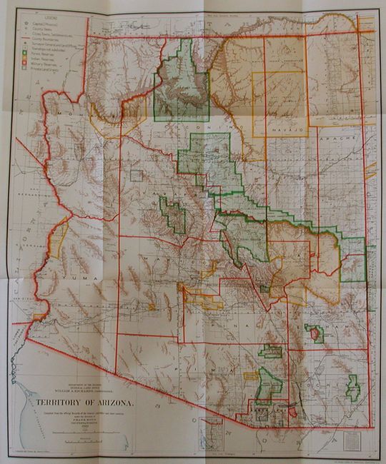
2. Territory of Arizona, Frank Bond, 1905, (17" x 20"). A colorful and fascinating map that provides a detailed look at the territory just seven years before statehood. The extent of nine Indian reservations and three Military reservations, including Fort Apache, and numerous National Forest Reserves are clearly shown in different colors. Private claims, confirmed and unconfirmed, are outlined in red. The Grand Canyon Forest Reserve is shown. Brown hachured mountainous areas and blue waterways combine to provide great visual impact. Details include watershed, mountains, railroads, wagon roads, private claims, unsurveyed townships, etc. This map initially appears identical to the 1903 edition, but closer study shows subtle but important differences. Drawn by Daniel O'Hare, and lithographed by the Norris Peters Co., Photo-Litho.
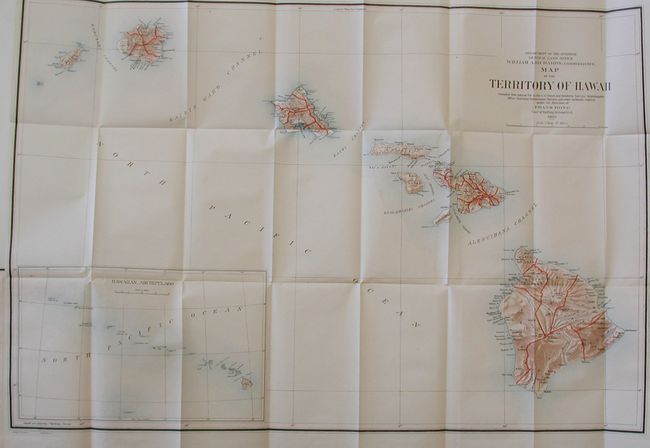
3. Territory of Hawaii, Frank Bond, 1905, (33" x 22"). A large, colorful map of the Hawaiian Islands developed shortly after annexation and with little settlement shown outside of Oahu. The Mauna Loa volcano is shown with its lava flows. The chart was "compiled from data on file in the U.S. Coast and Geodetic Survey: Hydrographic Office: Hawaiian Government Surveys, and other authentic sources under the direction of Frank Bond chief of drafting division." Published under the direction of the commissioner William A. Richards. A large inset, compiled by I.P. Berthrong (12.5 x 7.5"), gives a wider view of the entire archipelago, extending beyond Midway Island. Good detail on a scale of 1 inch = 12 miles.
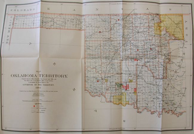
4. In 1905, the Five Indian Nations, concerned how statehood for Oklahoma might affect them, held a constitutional convention with the view to forming their own state. At the same time they partitioned their nations into 48 counties. But their efforts did not stop Oklahoma from becoming a state in 1907 and engulfing their lands. This map, Map of Oklahoma Territory, 1905, (21.5 x 14.5) details the region just prior to statehood. Compiled from the corrected map of the General Land Office and from data on file in the territorial office, it is filled with great detail, including railroads constructed and proposed, as well as roads and trails. It locates Indian lands including the Osage, Kansas, Creek, Choctaw, Pottawatomie, Comanche and others. Land Offices are located at Woodward, Alva, Guthrie, Kingfisher, Ft. Reno, Mangum and Lawton.
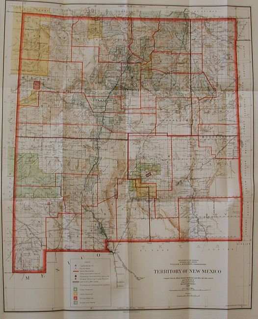
5. Territory of New Mexico, Frank Bond, 1903, (18" x 22"). This colorful and fascinating map was published only nine years before New Mexico obtained statehood. The extent of existing Indian reservations, Military reservations, Forest Reserves and Private Land Grants is shown through color and hash. Townships containing coal or probably containing coal are also colored, combining to provide great visual impact. The map is filled with information on watershed, mountains, railroads, wagon roads, unsurveyed townships, etc. In 1903, Guadalupe county was renamed Leonard Wood and then returned to Guadalupe in 1905. This is the only map we are aware of that shows that short-lived county of Leonard Wood.
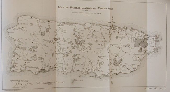
6. Map of Public Lands in Porto Rico, 1905, 13.8" x 7.2". This uncolored map details the entire island. Shaded areas with numbers refer to information in the text of the report.
References:
Condition: A+
The maps are all in fine, unopened condition. The contents are also fine and the covers are also near perfect.