Subject: New York City
Period: 1897 (dated)
Publication:
Color: Printed Color
Size:
22.5 x 8 inches
57.2 x 20.3 cm
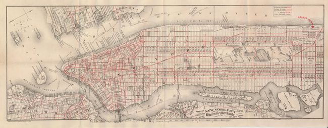
Apparently a pocket map, it covers Manhattan to 128th Street, parts of Brooklyn and New Jersey. The focus of the map is the extensive street transportation systems which are highlighted in red overprinting. Different line styles are used to delineate cable cars, surface and elevated railways and the steam railroads. Railway stations are identified. The location of Grant's Tomb is marked by a bold red star. The map extends to include Blackwell's, Wards, Randall's Islands, and parts of Jersey City and Brooklyn. The Brooklyn Bridge is clearly shown as "Suspension Bridge," the East River bridge is "under construction" and there is a "Proposed Bridge" above the location of today's Queens Midtown Tunnel. Blank verso. Covers not present.
To our knowledge this map represents the latest known work of George W. and Charles B. Colton. In American Maps and Mapmakers, Ristow says there is no known output by the firm after 1892 and that it is unknown if the firm expired on that year or was taken over by another company. We offered a pocket map of New Jersey a few years ago, the first time we'd seen a Colton dated 1897. This pocket map is the second 1897 edtion we've seen. A very late Colton issued map. The firm gives their address at 15 Warren Street, New York.
References:
Condition: A
With a short fold split at left margin and one fold intersection split.