Subject: Florida
Period: 1886 (dated)
Publication:
Color: Black & White
Size:
35.3 x 16 inches
89.7 x 40.6 cm
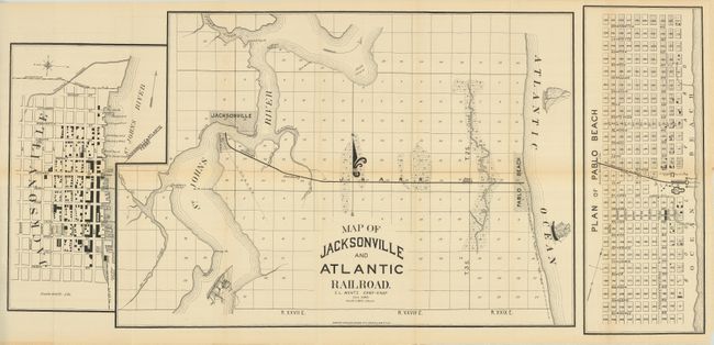
This map is actually three maps: the regional map, a town plan of Jacksonville, and a plan of Pablo Beach. he first shows the proposed rail line between Jacksonville and Pablo Beach at a scale of one inch per mile. The map locates Potsburg, McGuirts Creek, Saddler's Point and more. It has a large fleur-de-lys and two whimsically drawn ships in the Atlantic, one is the Mayflower. A steamship sails up the St. Johns River toward Jacksonville. The plan of Jacksonville is highly detailed with all streets named and many buildings located and identified. The wharf area is particularly detailed with each pier named including the Jacksonville & Atlantic Ferry's dock. The plan of Pablo Beach is equally detailed and on the same scale of 600 feet per inch. It locates the Pavilion, Pagoda and the Murray Hall Resort, which was complete destroyed by fire on the night of August 7, 1890. The fire also destroyed the railway station which was adjacent to the resort. This scarce map was issued by E.L. Wentz Chief Engr., and printed by Robert A. Welcke, Photo-Lith., New York.
References:
Condition: A
Folding as issued with a little fold toning, still very good.