Subject: Korea
Period: 1850 (circa)
Publication:
Color: Black & White
Size:
12.5 x 20.3 inches
31.8 x 51.6 cm
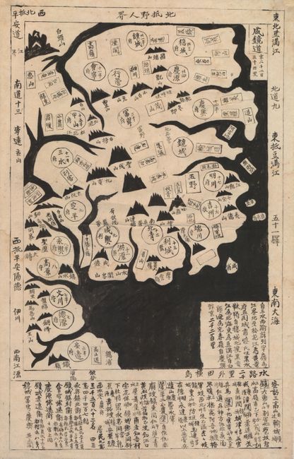
Most Korean origin maps found today are from the Yi Dynasty (1392 - 1910). It was the longest ruling Confucian dynasty that ended in 1910 with Japanese annexation. The maps from this period were produced by wood block or as hand-drawn manuscripts on mulberry bark or rice paper. The majority were produced with the toponyms in Chinese, the common language for intellectuals in Korea and Japan at the time. Many of the place names are from Chinese mythology dating to the third century B.C., suggesting the maps were used in the study of Chinese classics in addition to a contemporary geological resource.
Assembling maps into atlases was popular in Korea for several centuries, long before the practice was adopted in China or Japan. Produced in both manuscript and printed (wood-block) form, the atlases followed a common format, including a world map, separate maps of China and Japan, Korea and the Ryukyu Islands, followed by maps of the provinces of Korea. Despite their wide-spread use, most were destroyed following the Japanese occupation and thus are rare today.
Shannon McCune says "The calligraphy on the maps was often delicate and precise. The title of the maps were usually spaced artistically…Korea cartographers restricted themselves to the brushstroke drawing of mountains, mountain chains, and rivers and of towns, walls, temples, defensive outposts and signal-fire towers. The real beauty of the Yi dynasty maps of Korea is in their order and symmetry - both valued Confucian virtues." Ref: McCune, Shannon. "Korean Maps of the Yi Dynasty." Korean Culture 4:3 (September 1983): 21-31.
Fabulous, Korean wood-block map in heavy black ink. The map was produced in Korea with the toponyms in Chinese, typical of early Korean cartography during this period. It details the province of Hamgyong-do, first named in this form some time in the early sixteenth century. The explanatory text at the sides and below is also written in Chinese. The maps were used for study in most noble households during the late Yi Dynasty, but became unwanted when Japanese colonial rule began. Examples of these black and white wood-block maps are exceedingly difficult to find today.
References:
Condition: A
Small area of staining near center, else fine. Thick hand made paper with evidence of heavy fiber, probably either rice or mulberry paper.