Subject: England
Period: 1733 (circa)
Publication:
Color: Hand Color
Size:
20 x 16.5 inches
50.8 x 41.9 cm
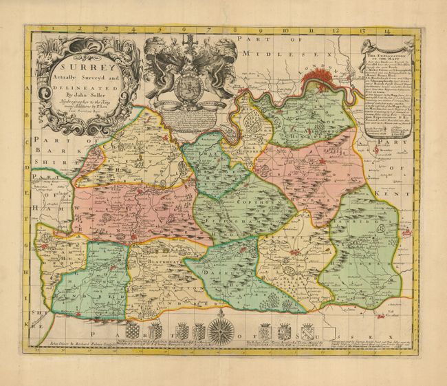
This stunning map of the county of Surrey is a very scarce and desirable map. Originally produced for Seller's proposed Atlas Anglicanus in circa 1680, the plate subsequently passed to Phillip Lea and finally to Thomas and John Bowles who issued this sixth and final state in 1733. The map provides super information on the county and includes a small plan of London. An elaborate title cartouche, the royal arms and a decorative key are arrayed across the top; eight family crests and a splendid compass rose grace the foot of the map.
John Seller was a pioneering British publisher of nautical charts and one of the most important figures in the early history of British cartography. Seller's shop, located near the Tower of London in Wapping, became a gathering place for seamen arriving with the latest news of distant places such as the West Indies and provided Seller with information critical to his nautical chart business. In addition to sea charts, he produced a vast array of cartographic material, the first to rival the large Dutch firms such as Blaeu and Jansson. Seller was appointed Royal Hydrographer by Charles II in 1671, and also served under James II and William III. Unfortunately his business was built on a shaky foundation and though he made several attempts to avoid bankruptcy including a consortium partnership with other cartographers such as William Fisher and John Thornton, he was ultimately unsuccessful.
References: Marsh (TMC-67) p. 55.
Condition: A
Great impression and original color. The paper is slightly toned, darker in margins.