Catalog Archive
Auction 125, Lot 432

"Vera Delineatio Totius Tractus ex Hollandia Septentrionem versus per Fretrum Nassovicum, ad Fluvium Oby Ducentes, ex Annotatione Iohannis Hugouis Lintschottani, de Annis 1594 et 1595", Bry, Theodore de

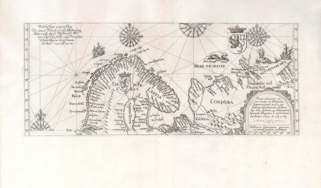
Subject: Arctic - Scandinavia

Period: 1613 (circa)

Publication: Petits Voyages

Color: Black & White

Size:
13.3 x 5.5 inches
33.8 x 14 cm
Download High Resolution Image
(or just click on image to launch the Zoom viewer)

This handsome, boldly engraved map is derived from Linschoten's important chart depicting the discoveries of Barent's first and second voyages to the Arctic in search of a northeast passage to Asia. The map provides excellent information on the northern coastline of Scandinavia to the west coast of Novaya Zemlya. It is richly adorned with compass roses, ships, coats of arms, seals, and sea monsters.

References: Ginsberg #49.2.

Condition: A+

Excellent impression on a fine sheet of laid paper with wide original margins.

Estimate: $800 - $1,000

Sold for: $1,600

Closed on 9/24/2008

Archived