Subject: Canadian Arctic, North Pacific and Northern Asia
Period: 1772 (dated)
Publication: Encyclopedie
Color: Hand Color
Size:
14.3 x 11.4 inches
36.3 x 29 cm
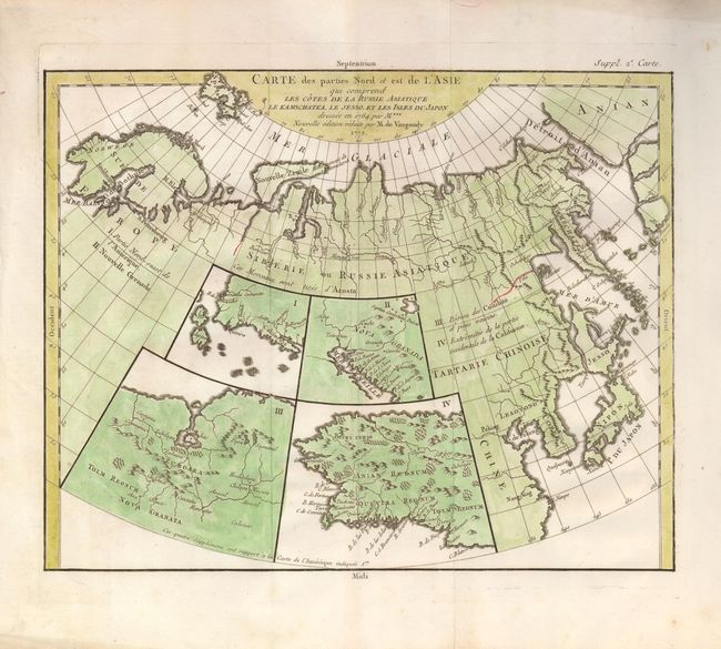
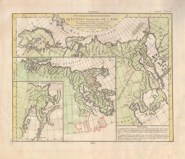
When Charles Joseph Panckoucke took over publication of Diderot's Encyclopedie in 1768, he promised to correct the cursory treatment of geography for which the first seventeen volumes had been criticized, with emphasis on the discoveries of the last 25 years. He employed Samuel Engel, a Swiss geographer, to write a series of articles about the northern regions and Didier Robert de Vaugondy to prepare ten maps to illustrate them. Engel rejected the De la Fonte Northwest Passage discoveries and believed the most sensible route from the Atlantic to the Pacific was along the north coast of Siberia. These maps illustrate the discoveries and various cartographic theories concerning the Pacific Northwest, East Asia and the North Pacific Ocean and include some of the most interesting comparative cartography of the eighteenth century
This intriguing pair of maps offers an informative overview of some of the early cartographic theories concerning the northern part of Asia and the western part of North America, as well as the Arctic search for a Northwest Passage.
1) Carte des parties Nord et est de l'Asia... This unusual map details the northern coastline from Scandinavia through to the eastern coast of Asia to just below Nanking, and a bit of the coast of America called Anian. Japan is shown with the imaginary island of Jesso above it. Inset into the map are four small maps of the western part of North America: I - Features the entire western coast with Japan just a short distance offshore. II - Focuses on Nova Granada showing the Mexican coast of the Gulf of California. III - Focuses on the Zubgara and Tolm Regnum of Nova Granada and the mythical seven cities of Cibola. IV - Covers Anian Regnum, which includes Quivira Regnum and another Tolm Regnum.
2) Nouvelle Representation des Cotes Nord et Est de l'Asie. This interesting map of the northeast coast of Asia depicts Kamchatka, Japan and Korea. It also shows part of what is present-day Alaska. The Tchutski (Chukotskiy) Peninsula stretches very close to the American landmass, hinting at a possible land bridge. Within the larger map are two insets (one within the other); each is a different depiction of Kamchatka.
References: Pedley #406 & 402.
Condition: A
Folding as issued with some soil and tape remnants in blank margins, well away from maps.