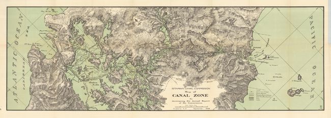
Subject: Central America, Panama
Period: 1908 (dated)
Publication: Isthmian Canal Commission
Color: Printed Color
Size:
36 x 12 inches
91.4 x 30.5 cm
This colorful and detailed map delineates the course of the proposed canal which was eventually opened in 1914. The map shows topography, the canal route, and railroads along the Panama Canal Zone. The legend locates the Center Line of Canal, Panama Railroad, Relocated Panama Railroad, Canal Zone Boundary Line, Dams, and Locks through line, color, and iconography. Congress authorized construction of a 'lock' canal in June of 1906. The United States had previously gained use of a ten mile wide "Canal Zone" in a series of negotiations and treaties, as well as purchasing the property of the French Canal Company. Drawn in September, 1908 in Culebra, Canal Zone. A scarce issue and an early look at construction.
References:
Condition: A+
Folding as issued.