Subject: Massachusetts
Period: 1817 (dated)
Publication: American Journal of Science 1818
Color: Hand Color
Size:
7.5 x 16.5 inches
19.1 x 41.9 cm
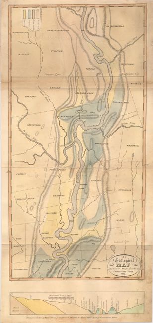
This is one of the earliest American geological maps, one year before by one by Maclure. It was published in the first volume of Silliman's renowned American Journal of Science, America's first scientific journal, in 1818. A scare issue for which we find no prior pricing information. The map details the Connecticut River valley from Hadley to Chesterfield counties. Legend uses hand coloring to locate Primitive Rocks, Primitive Argillita, Secondary; and Alluvial structures. Below the map in its own border is "Traverse Section of Rock Strata from Hoosack Mountain to Eleven Miles East of Connecticut River." A scarce issue.
References:
Condition: B+
Good impression and original color on thick sheet with original margins. Short fold split into map closed on verso. Some surface soiling or foxing.