Subject: United States
Period: 1854 (circa)
Publication:
Color: Hand Color
Size:
21 x 15 inches
53.3 x 38.1 cm
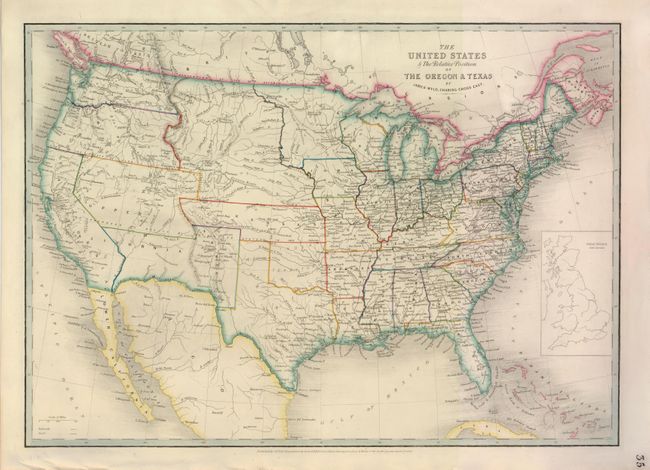
This is an updated version of this interesting map, first published in 1845 when the Oregon District was in dispute between the U.S. and Britain, and Texas had just been annexed. The map shows several previous and proposed western boundaries; Line Proposed by the Convention of the 20th October 1818 (the present boundary between the U.S. and Canada), Line of the Treaty of Florida 1819, Line Proposed to Mexico by the United Sates in 1835, and Boundary of 1848 (pre-Gadsden boundary between U.S. and Mexico). There are several large territories in the west with Washington having just been carved out of Oregon Territory, Utah and New Mexico having been formed from the eastern part of Upper California, and Kansas Territory having been created in the southern portion of Nebraska Territory. The panhandle of Texas is elongated to include the panhandle of present-day Oklahoma, which is here Indian Territory. The Oregon Route is shown crossing the plains and the only other transcontinental road shown is unnamed and apparently follows the route of the Stevens exploration for the Pacific Railroad. An inset of Great Britain on the same scale is in the Atlantic.
References:
Condition: B
There is a tear 3" into map at top with old paper repair on verso, else very good with nice original color.