Subject: World & Continents
Period: 1725 (circa)
Publication:
Color: Hand Color
Size:
13.5 x 10.8 inches
34.3 x 27.4 cm
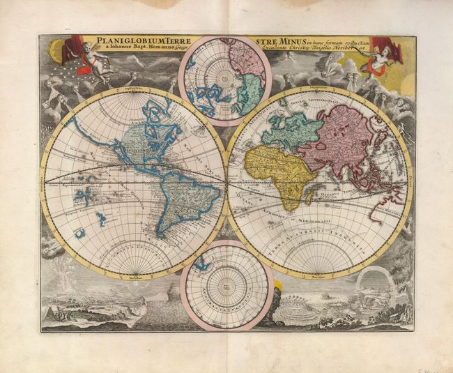
An uncommon matched set of maps with cartography based on that of Johann Baptiste Homann. The unusual original coloring uses small colored dots to indicate the locations of Catholics, Jews, Muslims, heathens, and other religions on the continental maps.
1) Planiglobium Terrestre Minus… is based on Homann's Planiglobii Terrestris Cum Utrog Hemisphaerio Caelesti. It is embellished with similar engravings of natural phenomena and the starry heavens. However, the map itself differs from Homann in that it presents an insular California and a different Terra Esonis with the Fretum Anian. The map also retains a faint outline of the great southern continent, Terra Australis Incongnita. Instead of celestial maps between the cusps of the double hemisphere map, Weigel has included terrestrial maps on polar projections.
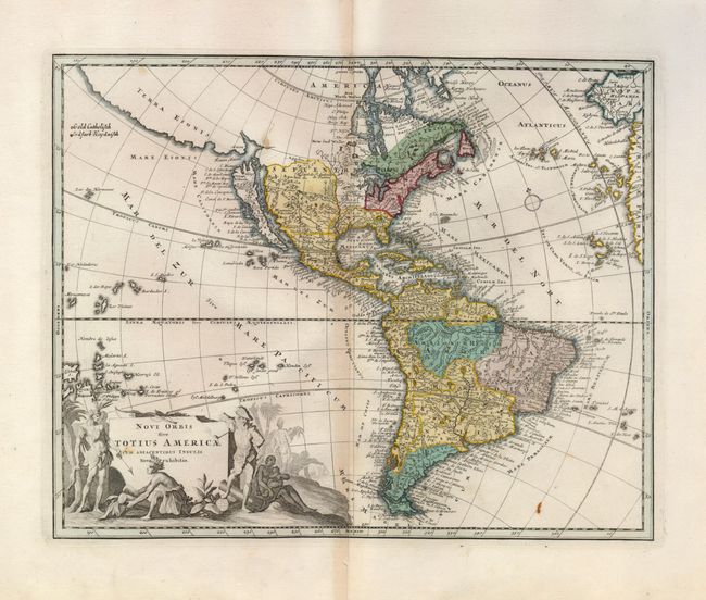
2) Novi Orbis Totius Americae… is a handsome map showing California as an island on the Foxe model with two bays on the north coast. Above California is a large, spurious Terra Esonis stretching across the northwest corner of the map. The fictional Lake May is shown in the Carolinas, here named as Acralague. South America is filled with engraved detail of towns and topography. A decorative cartouche showing a European smoking a pipe and natives trading tobacco completes the composition.
3) Africae Tabula depicts the continent in a way typical of the early 18th century with spurious topography in the interior. The source of the Nile is shown emanating from the Ptolemaic lakes of Zaflan and Zaire south of the equator. The cartouche is surrounded by natives, elephants, an ostrich and lion.
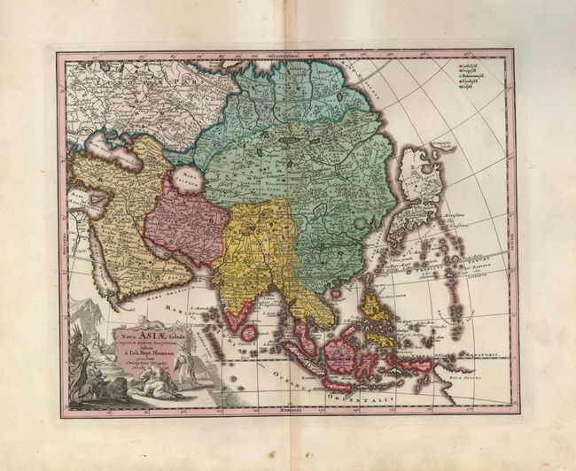
4) Nova Asiae Tabula… is a bold and very decorative map of Asia with a particularly interesting depiction of Japan. Hokkaido and Honshu (Terra Yedso) are joined together by a narrow isthmus and separated from the mainland by a wide strait. The Compagnie Landt from De Vries' exploration is shown as well. A tentative coastline for New Guinea is beginning to take shape. The decorative cartouche depicts Asians kowtowing before the emperor while a lion and a tiger look on.
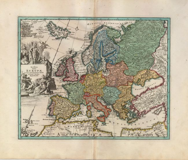
5) Novissima Totius Europae... shows all of Europe extending to Iceland and the coast of Greenland. An interesting Latin note on the amorphous, fictional island of Frisland mentions that this storied island has been completely submerged by the sea. The fantastic cartouche features an emperor, putti, and Europa being abducted by Zeus in the form of a bull.
References: 2) McLaughlin #204; 3) Norwich #58.
Condition: B+
Lovely original color on sheets with minor toning on the centerfold. Map 2 has a few spots, maps 3 and 4 with a tiny worm track on the lower centerfold, map 5 with some light pencil marks in Poland.