Subject: Martinique
Period: 1675-1768 (published)
Publication:
Color: Black & White
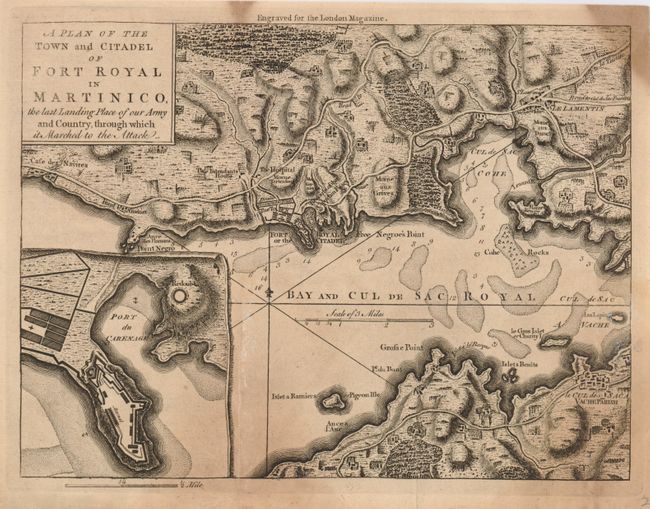
1) A Plan of the Town and Citadel of Fort Royal in Martinico, The last Landing Place of our Army and Country, through which it marched to the Attack (9.7 x 7.2") is a crisply engraved map that is after the 1760 edition by Jefferys. It details the bay and surrounding fortifications. There are towns, villages, roads, hospitals, churches and private estates shown. The topography is nicely illustrated with rivers, hills and forests. Locates Point Negro, Fort Royal (Fort-de-France), Free Negro's Point, Morne aux Dames, Morne Rouge, Vache Parish, Grosse Point and much more. An inset of Port du Carenage illustrates its fortifications. Rhumb lines, a distance scale and a fleur-de-lys embellish the map. From the April 1762 issue of London Magazine. Ref: Jolly LOND-211, Sellers & van Ee #2052. Some age-toning, soiling, and a fold split has been repaired on verso with tissue. Grade B.
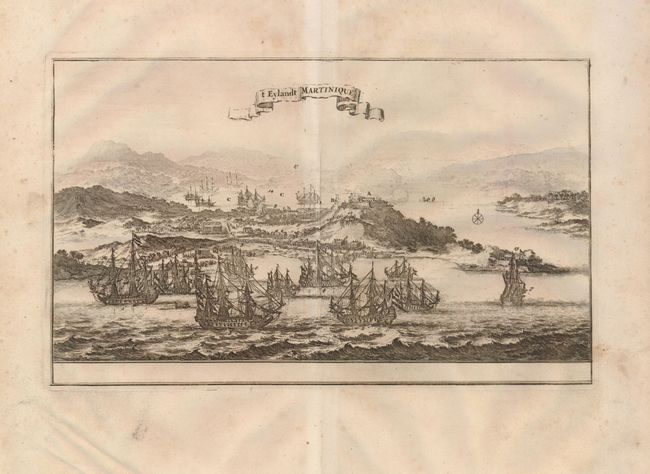
2) t Eylandt Martinique, published by van Mews & Sowerin, Amsterdam, circa 1675 (11.5 x 6.5") Nice view of the island and harbor illustrating Admiral De Ruyter's unsuccessful attempt to take the island from the French in 1674. The scene shows numerous ships preparing for battle, dozens of soldiers marching to the fight, and cannons firing on their enemy. The view has a simple compass rose, and numerous elements are lettered and numbered, but is without a key. A little foxing in map, more in wide margins. An extraneous crease along centerfold, which is less toned than the rest of the sheet. Grade B.
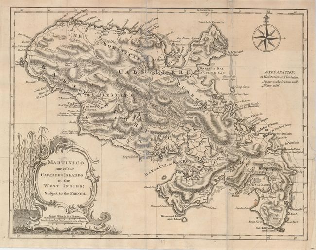
3) Martinico, One of the Caribbee Islands in the West Indies; Subject to the French, Thomas Jeffreys, London, 1768 (13.8 x 10.5"). Strongly engraved and detailed map of the island with roads, villages, mountains, rivers, and geographical features well shown. Drawn according to the observations of Mr. Houel. A key at upper right identifies plantations, sugar works, oxen mills, and water mills. Rococo-style cartouche and elegant compass rose adorn the map. Issued folding, now pressed. Several fold splits and edge separations, with minor loss, repaired with archival tape on front and back. Grade C+.
References:
Condition:
See description.