Subject: Indiana
Period: 1828 (published)
Publication: HR Doc. 25, 20th Congress, 1st Session
Color: Black & White
Size:
31 x 9 inches
78.7 x 22.9 cm
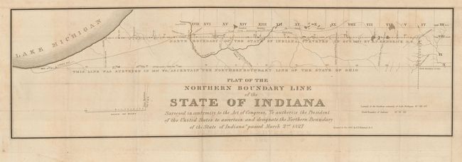
Surveyed in conformity with the Act of Congress, "To authorize the President of the United States to ascertain and designate the Northern Boundary of the State of Indiana" passed March 2nd, 1827. Map shows the 1827 boundary line surveyed by E. P. Kendrich and an earlier line to the north surveyed in 1817 to ascertain the northern boundary of the State of Ohio. Accompanied by the original four-page government report "Message from the President of the United States, with a Plat of the survey of the Northern boundary of the State of Indiana, December 12, 1827." First page is the transmittal signed in text "John Quincy Adams."
References: Karpinski (FC) #663.
Condition: B+
Map is a good impression with wide margins. It has some offsetting, else very good.