Subject: Alaska
Period: 1898 (dated)
Publication:
Color: Printed Color
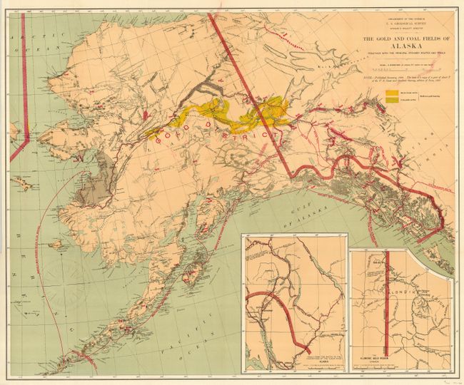
1) A fine geological map printed in the five-color lithographic method with considerable place name detail. The Birch Creek and Forty Mile gold regions are prominently shown. Strong red over printing is used to detail steamer routes, trails, and the gold regions. There are two insets: "Trails from the tide water to the headwaters of the Yukon River, Alaska" and "The Klondike Gold Region, Canada." The large Fort St. Michael Military Reservation is shown centered on Norton Sound. The monthly steamer routes servicing areas from Norton Sound, along the south side of the Aleutians and along the Alaskan Coast to San Francisco are shown. Note below the title indicates the map was published in January, 1898 and based in part on a portion of the 1897 Chart T of the U.S. Coast and Geodetic Survey. Published by the Department of the Interior, Charles D. Walcott, Director. A really nice example of this great map from the Alaskan Gold Rush period. (28.5 x 23.5") Very good to fine condition with a little color offsetting from the strong coloring, as is generally found on this map.
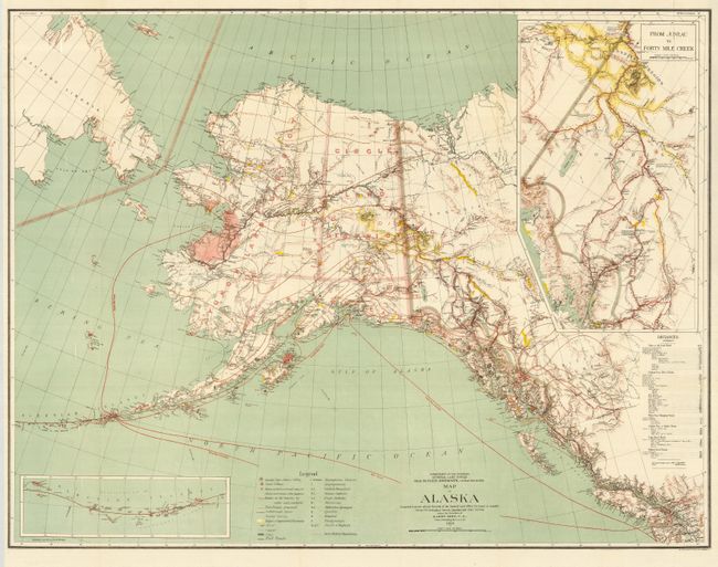
2) Large colorful map of the territory published at the beginning of the Yukon Gold Rush, published by the General Land Office in 1898. It is a large and colorful map of Alaska Territory features a large inset of the gold region titled "From Juneau to Forty-Mile Creek". A legend identifies regions with reported gold discoveries (highlighted in yellow), deposits of silver, copper and coal, church locations, and routes of the railroads (both existing and proposed). Another inset details the Aleutian Islands. Large text box provides distances from the U.S. to locations throughout Alaska, e.g. San Francisco to Chilkoot Pass - 1186 miles. Steam ship routes are detailed from San Francisco plus internal mail routes are shown in overprinted colors. Compiled and drawn by M. Herdges under the direction of Harry King, Chief of Drafting Division. (32.3 x 25") Fine condition.
The pair make a remarkable record of the great Alaskan Gold Rush.
References: Falk (AK) #1898-51; Phillips (AK) p. 117.
Condition:
See description.