Subject: North Pacific, Alaska and Arctic
Period: 1772 (published)
Publication: Diderot's Encyclopedie (Supplement)
Color: Black & White
When Charles Joseph Panckoucke took over publication of Diderot's Encyclopedie in 1768, he promised to correct the cursory treatment of geography for which the first seventeen volumes had been criticized, with emphasis on the discoveries of the last 25 years. He employed Samuel Engel, a Swiss geographer, to write a series of articles about the northern regions and Didier Robert de Vaugondy to prepare ten maps to illustrate them. Engel rejected the De la Fonte Northwest Passage discoveries and believed the most sensible route from the Atlantic to the Pacific was along the north coast of Siberia. These maps illustrate the discoveries and various cartographic theories concerning the Pacific Northwest, East Asia and the North Pacific Ocean and include some of the most interesting comparative cartography of the eighteenth century
Three great maps from this interesting series of map prepared by Didier Robert de Vaugondy.
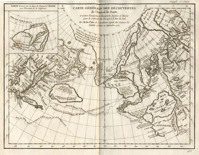
1) Carte Generale des Decouvertes de l'Amiral de Fonte, et autre Navigateurs Espagnols, Anglois et Russes… This is one of the more remarkable combinations of fact and fiction ever published. This map of the North Pacific and Northwest had as its source a 1708 article in the Monthly Miscellany that purported to be a newly discovered account of a voyage in 1640 by the Spanish Admiral, Bartholomew de Fonte. Thereafter, the newly presented information was changed and elaborated upon, notably by this series of maps which appeared in Diderot's Encyclopedia. In its concept, it promoted the hopes of a Northwest Passage and depicted the existence of Mer de l'Ouest or the Sea of the West. The tracks for the Russian exploration in 1741 and other explorers are traced in the Pacific. Inset at upper left is a small map, "Carte dressee Sur la lettre de l'Amiral de Fonte par l'Ecrivain de la Californie" detailing the purported track of Admiral de Fonte from the Pacific to Hudson Bay. (14.8 x 11.3") Ref: Hayes pp.26-27; Pedley #455. Near fine save one small spot of foxing in the inset map (B+)
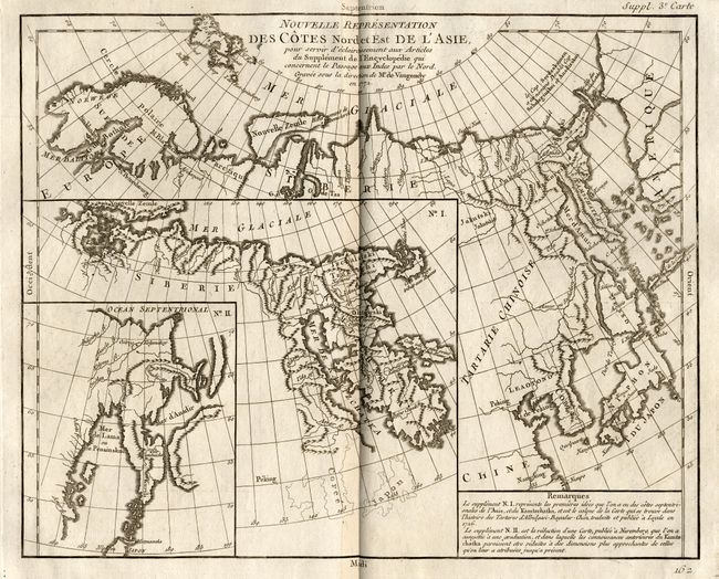
2) Nouvelle Representation des Cotes Nord et Est de L'Asie, pour servir d'eclaircissement… Interesting map of the northeast coast of Asia depicting Kamchatka, Japan and Korea. It also shows part of what is present-day Alaska. The Tchutski (Chukotskiy) Peninsula stretches very close to the American landmass, hinting at a possible land bridge. Within the larger map are two insets (one within the other); each is a different depiction of Kamchatka. (10 x 15.5") Ref: Pedley #402. (A+)
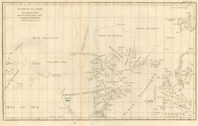
3) Partie de la Carte du Capitaine Cluny Auteur d'un ouvrage anglois intitule American Traveller. While this fascinating map covers the Arctic from Asia through Europe, the focus of the map is the Arctic region of North America. The most important feature of the map is the early depiction of what is present-day Alaska, patterned after Muller's epic map of 1750 that was the first to show the Russian discoveries, also noted here. A very interesting Northwest Passage is shown going from Repulse Bay in the north part of Hudson's Bay into the Arctic Ocean at Cape Fowler. (19 x 11.5") Ref: Pedley #460. Faint toning along folds, else fine. (A)
References:
Condition:
see descriptions