Subject: Western Hemisphere
Period: 1540 (published)
Publication: Cosmographia
Color: Hand Color
Size:
13.5 x 10 inches
34.3 x 25.4 cm
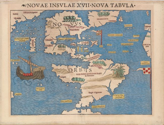
Extremely scarce, first edition of this important 16th century map of the New World. This map is often credited with popularizing the name America due to the popularity of Munster's Cosmographia. North America is very oddly shaped with no California and Zipangri (Japan) is shown only a short distance off the western coast. The influence of Marco Polo's 13th century explorations in Asia are evident with the 7448 islands in the North Pacific. In the eastern part of North America, the land is nearly bisected by a body of water, known as the Sea of Verrazzano. The Yucatan is still shown as an island, Cozumel is named nearby as Cozumela, and the lake at Temistitan is connected to the Gulf of Mexico. South America has a large bulge in the southwest, the Amazon River is very short, and cannibals inhabit the continent shown with the name Canibali next to a gruesome vignette with human limbs. The map is very decorative with Magellan's surviving ship Victoria appearing in the Pacific. The flags of Spain and Portugal depict their respective spheres of influence in the New World.
References: Burden #12.
Condition: A
A handsome example on a sheet with a few minor creases. Margins with some faint mat burn.