Subject: United States
Period: 1878 (circa)
Publication: Stanford's Geography
Color: Printed Color
Size:
26 x 9 inches
66 x 22.9 cm
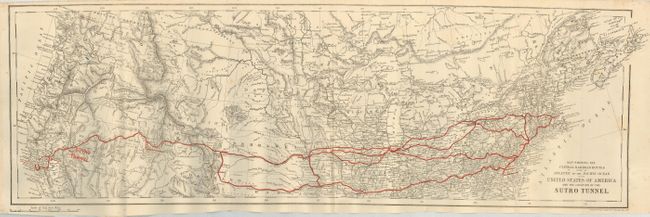
This uncommon map covers the northern two-thirds of the U.S. as it details the newly-completed trans-continental railroad. The railway and connections stretch between Boston and San Francisco, and are highlighted in red overprinting. The Sutro Tunnel figures largely on the map as it is the only feature with large red overprinting. The tunnel was envisioned by Adolph Sutro in 1860 to help drain excess water from the Comstock Lode to facilitate ore removal. The tunnel, which is six miles long, begins at Virginia City and ends near the town of Dayton, Nevada. Completed in 1878, Sutro immediately sold his interest in the tunnel and moved to San Francisco, later becoming its mayor. This is the only large-scale map we know of that celebrates the tunnel and the engineering feat it represents. Much of the investment money for the tunnel came from England, which lead to Stanford's publishing the promotional brochure and map.
References:
Condition: B+
Folding as issued with a dark impression. A little marginal foxing with one area extending into border.