Subject: North America
Period: 1836-1839 (circa)
Publication:
Color: Hand Color
The United States and Great Britain established in 1818 joint claim over the Oregon Territory - the region north of Spanish controlled Upper California up to the southern boundary of Russia's Alaska Territory at North latitude 54°40'. By the late 1830's this arrangement was beginning to fall apart.
In the 1840's the expansionist Democrats, including their 1844 presidential candidate, James Polk, claimed the entire region for the United States. Their expansionist desires were expressed by Polk's famous campaign slogan, "Fifty-four Forty or Fight!" The slogan also became a rally cry for Americans desiring to settle the territory. Following Polk's election, the dispute was resolved by the 1846 Treaty of Oregon, which struck a compromise that fixed the U.S./Canadian boundary at 49º North.
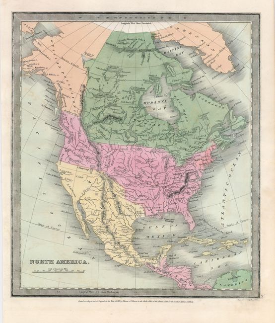
An attractive pair of maps detailing North America in the middle of the 19th century.
1) Map of North America Designed to Accompany Smith's Geography for Schools is a very nice and early example of this copper engraved map that features the Independent Republic of Texas. Austin is appropriately noted as the capital with a large star. The entire western region is mostly unsettled with only a few place names including St. Francisco, Monterrey, St. Diego and Albuquerque. In the vicinity of Santa Barbara is St. Louis, a name we've not see on any other map. Alaska is a large blank area labeled Russian Possessions with the notation Unexplored Region, and Canada is labeled New Britain as well as British America. In the Northwest, the U.S. extends well up into Canada to the 55th parallel, an early indication of the tensions between the United States and Britain in their claims in the region. Mexico controls the entire Southwest and California up to the 42nd parallel. The Great Basin area is shown as the huge Great Sandy Plains, and the Great Salt Lake is too far to the east and simply called Salt L. The map extends to include Greenland, Central America and the Caribbean. By David Burgess, dated 1839 (8.3 x 10.5").
2) North America was published by Illman & Pilbrow, but the map is by David Burr. It shows the extended Northwest Boundary up to the 55th parallel, and simplified topography with some placenames in the continent. Texas is still considered a part of Mexico; this map is dated 1836, the same year that Texas claimed its independence (10.8 x 12.3").
References:
Condition: A
Map 1 with some minor marginal tears on the right, not affecting the map. Map 2 with a little irregular toning.