Subject: North Pacific Ocean
Period: 1784 (dated)
Publication: Atlas Universel
Color: Hand Color
Size:
25.3 x 19 inches
64.3 x 48.3 cm
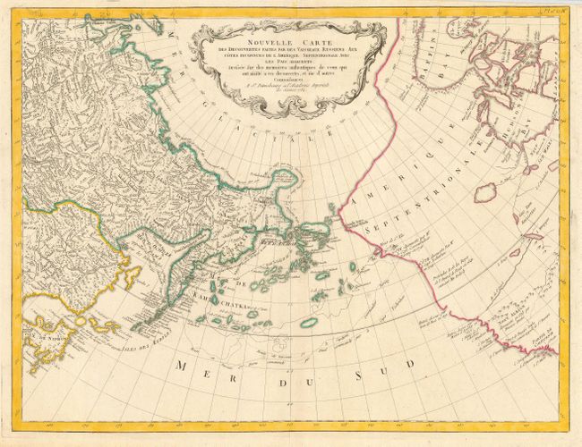
This map is an updated version of Gerhard Muller's landmark map of 1754 showing the discoveries of Captains Bering and Tschirikow. Muller was a German scholar who worked for the Russian Imperial Academy of Sciences. He originally published his map in response to Joseph Delisle and Philippe Buache's map that showed previously unknown Russian discoveries and an elaborate (and entirely speculative) depiction of the imaginary voyage of Admiral De Fonte through a Northwest Passage. Muller's original version showed an elongated landmass roughly in the shape of the Alaskan Peninsula and the Aleutian Islands. The map was updated several times, most significantly in 1773 after the expedition of Lt. Ivan Synd in which the elongated peninsula was shortened in favor of a large group of islands. Interestingly the speculative Northwest Passage is still shown connecting to Hudson Bay via a mythical River of the West . Muller's map was copied numerous times by different publishers due to increased interest in the region and the De Fonte controversy. This is the Santini/Remondini edition of state 3 of Muller's map (1773). It will be an uncommon and fascinating addition to any collection of the Pacific Northwest.
References: Hayes p. 29-32; Kershaw #1146; Verner & Stuart-Stubbs #38, p. 272-75; Wagner #633.
Condition: A
Dark impression. Top margin trimmed for binding, but still adequate for framing.