Subject: Massachusetts, Salem
Period: 1834 (dated)
Publication:
Color: Black & White
Size:
26 x 21 inches
66 x 53.3 cm
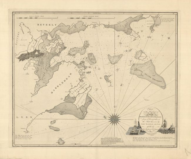
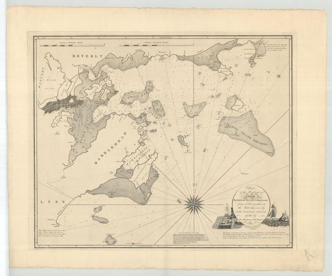
This is an extremely rare, separately issued map of the coasts and harbors of Salem, Beverly, Marblehead and Manchester. The second edition of this map, originally published in 1806, it includes additions by Charles M. Endicott and Joseph Perkins, Jr. In 1804, Nathaniel Bowditch undertook the task of surveying the waters around Salem, as he found the existing charts to be insufficiently detailed or accurate. He put together a small team of assistants and they spent eighty days mapping the waters from Gale's Point to Manchester. The map is filled with information on soundings, hazards, and anchorages, and it includes Baker's Island, House Island, Cat Island and the Misery Islands. Both Salem Neck and Marblehead Neck are well delineated, and the coastal areas include notes of interest, including Thissel's House, and Phillip's house, beach and point. Bowditch's map was so accurate that the old pilots complained that since all their professional secrets were now included on the chart, their services would no longer be needed to navigate the hazardous shipping lanes. The cartouche is decorated with a scene of a lighthouse, ship and port. The map was crisply engraved by Hooker and Fairman. This chart is exceedingly rare in any issue. This example has been in the possession of the same person who purchased it from R.V. Tooley in 1965.
Nathaniel Bowditch (1773-1838) was born in Salem, Massachusetts to a family of coopers. He was largely self-taught in navigation, classical languages, and mathematics, and became captain of a merchant ship that voyaged from the East Indies to Europe. During those voyages, he compared his navigational information with that of John Hamilton Moore's The Practical Navigator, and found more than 8,000 errors. In 1799 he issued a revised edition of Moore's work, entitled The New Practical Navigator. In 1802 the first edition of Bowditch's American Practical Navigator was published. It became the shipping industry standard in the Western Hemisphere for the next century and a half.
References: Guthorn, p.34; Garver (Surveying the Shore), p.51.
Condition: A
A velvety impression on a thick sheet with some minor creases. The lower right margin has a repaired hole, well away from the map. There are a couple of soft creases and some minor fraying in the margins, which is not uncommon on a separately published map.