Subject: United States - Mid-Atlantic
Period: 1863 (dated)
Publication:
Color: Black & White
Size:
38 x 25 inches
96.5 x 63.5 cm
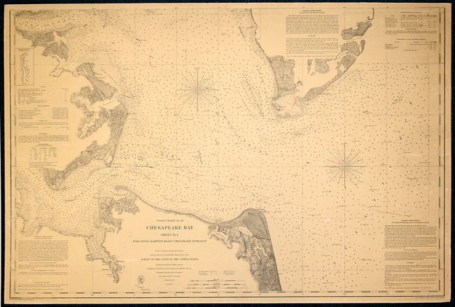
This is a scare, separately issued Civil War survey chart filled with soundings, sailing directions, lighthouses and tides delineated. The title continues "From a trigonometric Survey under the direction of A.D. Bache Superintendent of the Survey of the United States Triangulation by E. Blunt & J. Farley Assistants Topography by J.J.S. Hassler G.D. Wise J. Seib Assts. & J. Mechan Sub-Asst. Hydrography by the party under the command of Lieut. Comdg. J.J. Almy U.S.N. Assistant Published in 1863." This unfolded example is the first edition, published in 1863, not the later and more common issue that carries the additional names of J.W. Donn and W.W. Harding. Verified by J.E. Hilgard. Filled with details including sounds and extensive notes on Sailing Directions, Tides, Currents, Dangers, Lighthouses and Beacons, and more.
References:
Condition: B
An example with even, attractive age toning. The map has been mounted on a thin board.