Subject: Northern United States - Railroads
Period: 1882 (dated)
Publication:
Color: Printed Color
Size:
42 x 15.5 inches
106.7 x 39.4 cm
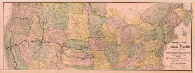
Attractive and colorful railroad map and timetable showing the United States from coast to coast, and the many railroads that served it, but focusing on the Union Pacific lines. Extends to include part of Canada, but only continues south to include, for example, only the northern parts of Arizona, Oklahoma, and North Carolina. Each station is located and named along the routes, with major stations in bold. Large and very decorative compass rose floats in the Atlantic. Folds into light pink pictorial covers with 18 panels of timetables and associated travel information. The cover features an engraved elevation of the Union Pacific Depot in Denver. Dated January, 1882. A very nice example considering these timetables are generally found in rough condition.
References:
Condition: A
A near fine example with bright color and clean paper less a couple small fold intersection splits with archival tape and a couple spots in blank areas at lower right.