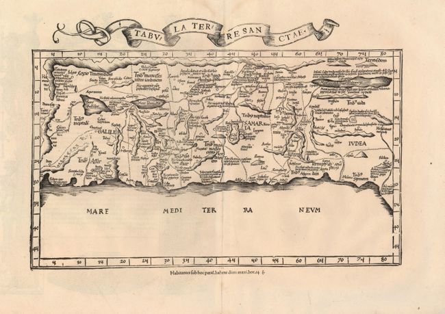
Subject: Holy Land
Period: 1535 (published)
Publication: Claudii Ptolemaei Alexandrini Geographicae…
Color: Black & White
Size:
16.3 x 9.5 inches
41.4 x 24.1 cm
This important map of the Holy Land is based on the first 'modern' depiction of Palestine by Sanuto-Vesconte in 1320. The map is divided into the Twelve Tribes of Israel. It depicts the coast oriented east at top, in a configuration that set the standard for maps of the region for the next 150 years. This particular example has the quote on the verso that was used against the editor Michael Servetus as one piece of evidence in his heresy trial. The offending statement indicated that according to modern travelers Palestine was not as fertile a land as was reported in the Bible. Ironically, Servatus was not the author of that quote and had only copied it from the previous 1525 Pirckheymer text. On Calvin's orders, many copies of this edition were burned at the same time as Servetus met his end at the stake in 1553; thus this edition is very rare. Latin edition, published by Melchior and Gaspar Trechsel.
References: Laor #612; Mickwitz & Miekkavaara (Nordenskiold ) Vol. II, #209:37; Nordenskiold pp. 22-23.
Condition: A
Nice impression on a sound sheet with wide original margins. Very faint damp stain at top margin, not affecting map.