Subject: United States
Period: 1874 (circa)
Publication:
Color: Printed Color
Size:
36 x 17.6 inches
91.4 x 44.7 cm
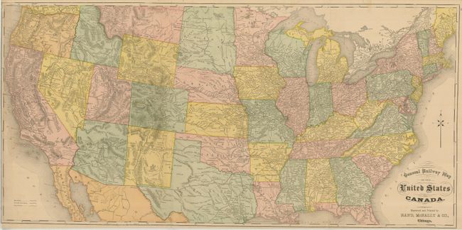
This is a large, early Rand McNally railroad map. The double-page map has a folding third panel to accommodate its length. Filled with railroad information throughout the country, with the exception of Florida, which is not shown below about Orlando. Indian Territory occupies the panhandle and Dakota is a single large territory. Rand McNally used an interesting projection which slightly distorts the rectangular states and territories into trapezoids. Prescott is shown as the territorial capital of Arizona (1877-1889), but we find credible references that include this map with county and other atlases as early as 1874, making this a very early Rand McNally production. Prescott was also the capital between 1863 - 1867 so perhaps the capital notation is a mistaken reference to older information. Another suggestion of the date is that Yellowstone National Park is simply called the "US National Park," an obvious early reference to the park which was established in 1872. Fancy lettering in title. Blank verso. Engraved by C.H. Waite. An uncommon issue that is not in Philips Maps or America or Modelski.
References:
Condition: B+
Very nice example with one area at extreme left of offsetting or toning. Close trimmed at left just to border, as issued.