Subject: World
Period: 1540 (circa)
Publication: Geographia
Color: Hand Color
Size:
13.5 x 10.25 inches
34.3 x 26 cm
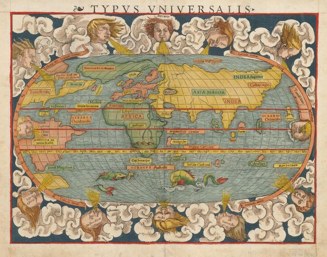
First state of Munster's 'modern' map of the world presented on an oval projection surrounded by vigorous clouds and wind heads. North America is shown with the large cleft nearly separating the east coast from the continent, often referred to as the Sea of Verrazano, and a Northwest Passage stretches towards Asia with a note in Latin that it leads to the Moluccas. The lands in the Arctic are all joined together in one large promontory that includes Iceland and Scandinavia with the name of Terra Nova sive Bacalhos. Terra Florida and Francisca are the only place names on the eastern portion of North America, while the western coast is filled with the name of Temistitian. South America is shown in an ungainly shape labeled America seu Insula Braslii, with the Strait of Magellan noted below. In Africa, the Nile is prominently shown with its twin sources beginning in a range of southern mountains. The mythical islands of Grisonum and Calensuan are placed in the proximity of Australia. The Pacific Ocean is named for the first time on a printed map as the Mare Pacificum. Zipangri is noted for Japan, and the island of Taprobana (Sri Lanka) is named off the coast of India. A sailing ship and several fierce sea monsters occupy the oceans. Latin text on verso.
References: Shirley #77.
Condition: A
Excellent impression and color. There is a small stain on the verso that shows through very faintly near the southern tip of Africa.