Subject: Barbados
Period: 1657 (published)
Publication: A true & exact history of the island of Barbados
Color: Black & White
Size:
20.3 x 14.5 inches
51.6 x 36.8 cm
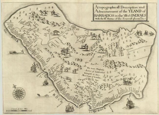
This is the earliest printed map exclusively of the island of Barbados. Lignon based his map on information given him by Captain John Swan, the island's leading surveyor of the time. The map depicts the island's outline fairly accurately, but makes it about a third longer than its correct length. The map identifies 285 plantations by the owner's name. The majority of the plantations are along the south and west coasts. Four churches are shown and there are fortifications at Carlisle Bay protecting the island's principal town, Bridgetown. In the middle of the map is the notation, "the tenn Thousande Acres of Lande which Belongeth to the Merchants of London." This is a reference to the land leased by Lord Carlisle to a group of merchants after Charles I rescinded the original grant of the island to Sir William Courteen. Scattered throughout the interior, most of which was overgrown with primeval forest, are quaint vignettes of the island's inhabitants and wildlife. There are knights in full armor, indentured servants, and a scene of a plantation owner chasing runaway slaves. The animal life is also illustrated; cattle, sheep, asses, wild hogs and even camels. Besides the hogs, which had been introduced to the islands by the Portuguese in the 16th century, the other animals had been brought to the island by the English settlers, including the camels that were used as beasts of burden on the plantations. According to Lignon, "several planters imported these beasts and found them useful in Barbados, but did not know how to diet them."
Richard Ligon was a Royalist who escaped some of the troubled politics of England in the 1640s by spending three years in Barbados. In 1650 he returned to England where he was thrown into debtors prison. He wrote his account and drew this map while in prison and it was published by Humphrey Moseley in 1657.
References: Campbell (MCC-21) p. 9, #1.
Condition: A+
Fine impression printed on hand-laid paper with narrow margins, as issued. Issued folding, now pressed and ready for framing.