Subject: Colonial South Carolina
Period: 1696 (circa)
Publication:
Color: Black & White
Size:
23.5 x 19 inches
59.7 x 48.3 cm
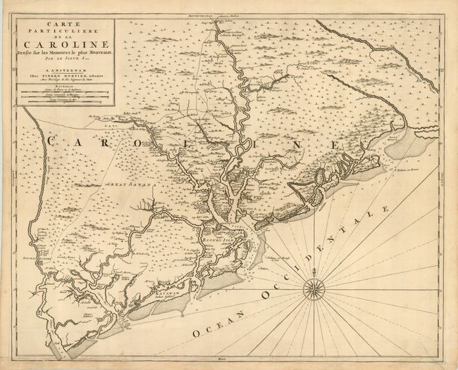
This important, scarce map of the coastal region around Charleston is based on the extremely rare Thornton-Morden chart of circa 1695, which in-turn was based on a manuscript map by Maurice Mathews [1685]. Centered on Charleston and the Cooper River, the map extends from the Edisto River in the south to the Santee River in the north. It provides the names and locations of dozens of early landowners around Charleston and along the coastlines and the major rivers. It also notes a number of Indian villages and shows early roads in the interior. The Santee Indian Fort, Farelaunes [Fairlawn], and the homestead of Maurice Mathews are depicted in Colletons Barony along the Cooper River. Sir John Colleton was one of the eight proprietors of the Carolina Grant, a member of the Council for Foreign Plantations and of the Royal African Company, which introduced slavery into the British possessions in North America. First state, lacking the plate number that was added to the second state. This is a foundation map for Carolina map collections as it is generally regarded as the first obtainable map of the region to appear in a commercial atlas.
References: Cumming, W.P. (SE) 121; Potter, J. p.20.
Condition: B
Dark impression printed on sturdy hand-laid paper. There is an old repaired tear entering map 1-1/2" at lower right with some minor abrasions along bottom border due to binding along that edge.