Catalog Archive
Auction 119, Lot 296

"Historical Map of Nantucket. Surveyed and Drawn by The Rev. E. C. Ewer D.D.", Railroad Companies, (Various)

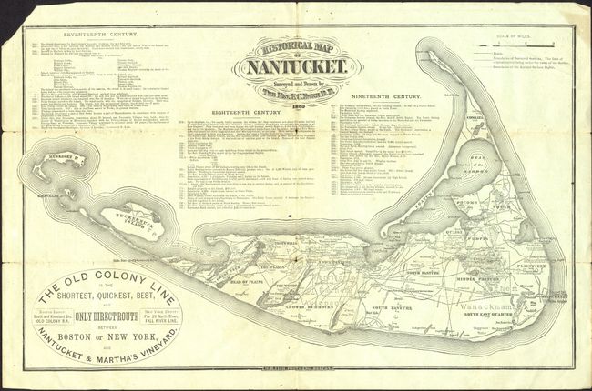
Subject: Massachusetts, Nantucket

Period: 1879 (dated)

Publication:

Color: Black & White

Size:
13.5 x 8.5 inches
34.3 x 21.6 cm
Download High Resolution Image
(or just click on image to launch the Zoom viewer)

This ephemeral pocket map advertises "The Old Colony Line is the Shortest, Quickest, Best, and Only Direct Route between Boston or New York, and Nantucket & Martha's Vineyard." The map is a reproduction of the one surveyed and drawn by the Rev. F.C. Ewer in 1869 and shows roads, villages and the boundaries of the Ancient Sachem Rights. It also includes a chronology of events from 1602 to 1877. It folds into a pocket brochure with advertising for the seaside resorts of Oak Bluffs, Martha's Vineyard, Nantucket and Cape Cod.

References:

Condition: B

Loss of upper left corner, just outside neatline. Light toning on folds with a small fold intersection split.

Estimate: $150 - $200

Sold for: $325

Closed on 5/9/2007

Archived