Subject: Europe
Period: 1764 (dated)
Publication: Continuation of Mr. Rapin's History of England
Color: Black & White
The lot includes a great plan of Barcelona and another of Turin. The lot includes:
1) Title page, Vol. III. (9.5 x 15") Beautiful and bold in red and black ink and a lovely copper engraved vignette showing allegorical figures. Surface soiling or foxing, edges frayed with some loss in bottom right.
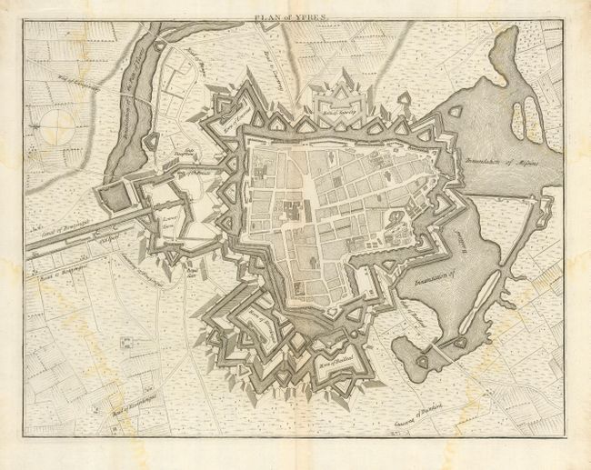
2) "Plan of Ypres" (16.3 x 12.6"). Interesting and detailed plan of the city, its walled fortifications and surrounding farmland. Damp staining at each corner reaching into image.
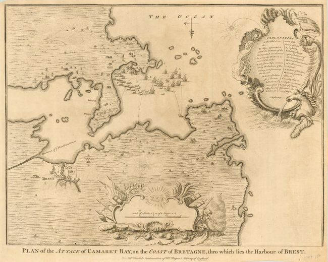
3) "Plan of the Attack of Camaret Bay, on the Coast of Bretagne, thro which lies the Harbour of Brest". (18.5 x 14"). Detailed map of the coast of Brittany centered on Brest Harbor, showing the English attack on Brest in June 1694. The English fleet is shown under fire from the harbor defenses, and is about to make for open sea, in retreat. Includes an explanation of the battle, military positions, numerous ships with the trajectories of the mortars coming at them and two decorative sea-shell style cartouches. Crisp Impression with very light soiling.
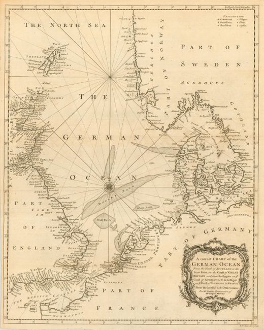
4) "A correct Chart of the German Ocean From the North of Scotland to…ye Coast of Normandy in France". Very nice chart showing numerous place names and featuring a rococo style cartouche and a key explaining the locations of villages, cities, forts, castles and ports. Rococo-style title cartouche and nice compass rose. Upper margin at little rough.(14.8 x 18.5")
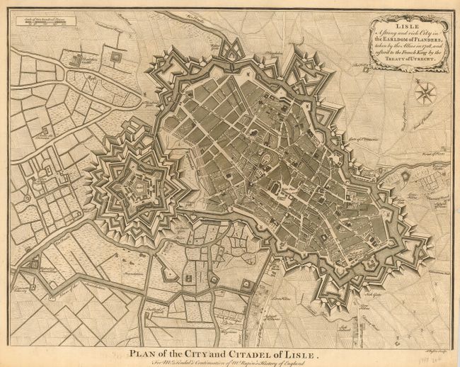
5) "Lisle A strong and rich City in the Earldom of Flanders, taken by the Allies in 1708, and restor'd to the French King by the Treaty of Utrecht." Elaborate plan of the fortifications and city of Lisle, and the surrounding countryside, roads, canals, etc. Decorated with a title cartouche and compass rose. Title at bottom: Plan of the City and Citadel of Lisle. (18.5 x 14.2")
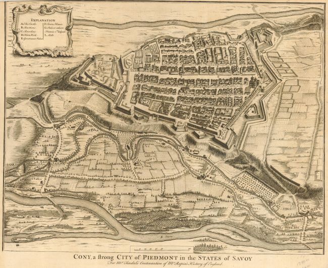
6) "Cony, a strong City of Piedmont in the States of Savoy" is a fine bird's-eye view of the city and fortifications of Cuneo and the surrounding countryside, canals and river, fields and houses. A decorative cartouche encloses a key to the map that locates the castle, churches, batteries, government buildings and mills. Upper margin trimmed into neat line at left corner. Close trimmed at top margin, as issued. (18.3 x 14.3")
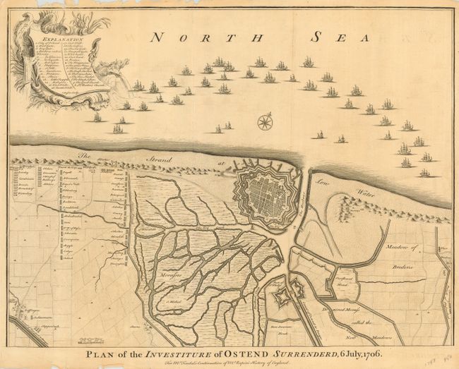
7) "Plan of the Investiture of Ostend Surrendered, 6 July 1706". This is a very attractive map of the fortified town Ostend, the Fort St. Philip, and surrounding countryside and sea. The map illustrates an important battle in the War of Spanish Succession. A fleet of ships is shown along the coastline and a huge army in the west is advancing on the city. A decorative cartouche contains a legend and the title is at bottom. Engraved by J. Basire. Fold separation reaching into image at bottom, upper margin with some fraying and chipping. (18.5 x 15")
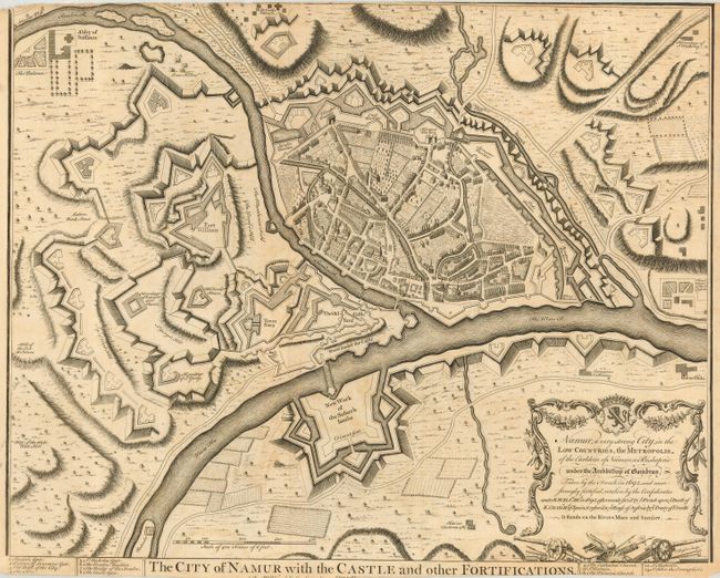
8) "The City of Namur with the Castle and other Fortifications...". A detailed plan with that shows an amazing amount of fortification surrounding the city. Numbered list at lower left identifies eight important buildings. The inscription that is part of the title gives a brief history of the city. Top and bottom margins close trimmed, as issued. (19 x 15.5")
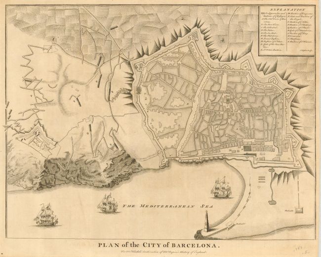
9) "Plan of the City of Barcelona". Boldly engraved plan of Barcelona that shows a meticulously detailed walled city, surrounded with a patchwork of fields and the hill with fortifications to the south. Numerous fortifications are located, and there is a lettered key describing twenty-one of the main buildings and roads. Three sailing ships under full sail are shown in the harbor. Some light soiling. (18.4 x 14")
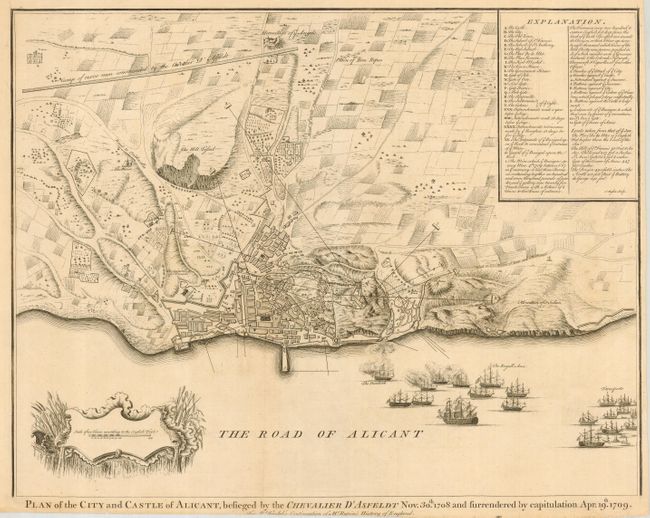
10) "Plan of the City and Castle of Alicante, besieged by the Chevalier D' Asfeldt Nov. 30th 1708 and surrendered by capitulation Apr. 19th 1709". Detailed plan of this Spanish Mediterranean city and vicinity, with fortifications, troop positions, ships in the harbor, etc. The view depicts the siege of Alicante by the French fleet during the War of the Spanish Succession. Lower and right margins close trimmed, as issued. Some fold splits or short tears in lower margin, closed on verso with archival tape. (18.5 x 15")
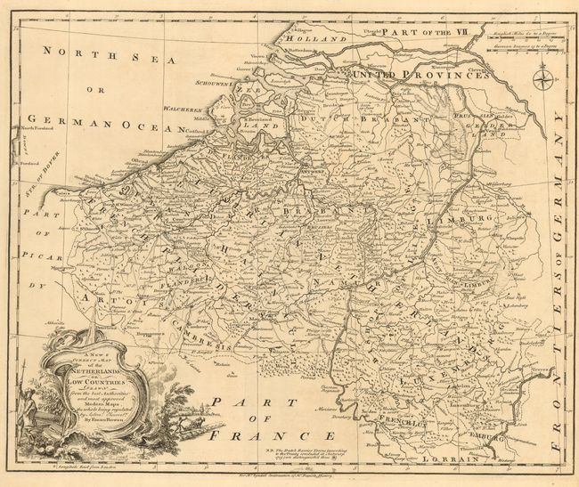
11) "A New & Correct Map of the Netherlands or Low Countries…" Well engraved and detailed map with a decorative cartouche. Extends north to include Rotterdam and the Hague. Notation gives special icon to identify the "Dutch Barrier Towns (according to the Treaty concluded at Antwerp 1715)." Finely engraved by Emanuel Bowen. Right margin close, as issued, near fine example. (16.5 x 13.5")
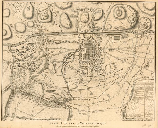
12) "Plan of Turin as Besieged in 1706". Incredibly detailed plan of the attack against the city which shows the encampments and positions of the invading armies encircling the city. Extensive legend identifies thirty-nine troop positions, batteries and more. Several tears in lower margin some recently repaired on verso with tape.(18.5 x 14.3")
13) " Plan of the Works of the City of Messina, one of the strongest and most considerable Cities of Sicily, and a fine Sea-Port". Finely engraved plan detailing the attack against this port city. Features numerous ships engaged in battle, and an extensive table with in a rococo-style cartouche locating forty-four important places and military positions. Small hole in upper left corner of map. Some splits or short tears in lower margin. ( 18.5 x 14.3")
14) "Plan of Toulon, with a View of its Road, and the Situation of its Towns, &c." Very attractive and detailed map of Toulon, its harbor and surroundings. Shows the defenses and military operations of the besieging allied force in 1707. (18 x 15")
15) "Plan of the Glorious Battle of Hochstet gained by the Allies on August 13th 1704". The most famous victory of John Churchill, 1st Duke of Marlborough, and Eugene of Savoy in the War of the Spanish Succession. It was the first major defeat that the French army suffered in over 50 years. Crisp, dark impression. (14.8 x 18.5")
Each of these plans provide a wealth of information, and are presented uncolored as issued. A great lot of fifteen maps and plans.
References:
Condition: A
The maps are generally very good, with a few just good due to water stain or surface soiling as noted in description.