Subject: Canadian Arctic, Hudson Bay and Alaska
Period: 1775 (dated)
Publication: The American Atlas
Color: Hand Color
Size:
43.5 x 18 inches
110.5 x 45.7 cm
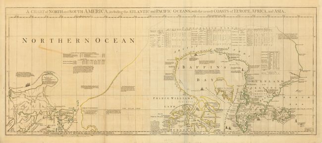
This is the top sheet of Jeffreys' large and important, three-part map of the Americas. This is the portion focused on the Arctic explorations into Hudson and Baffin Bay and on the Pacific Northwest coast. It is a complete map that stands on its own, with full margins and borders. The map is quite detailed, with a plethora of information on the explorers and their discoveries shown in various ways throughout the map. The tracks of Hudson and Baffin are shown and accented with sailing ships. Of particular interest are the tables of charts at the top and left, which show the variations in latitude and longitude between Jeffreys' chart and those of Bellin, D'Anville, Moll and Senex. There are indignant notes on the Pacific Northwest - "These parts, as yet wholly unknown are filled up, by Messrs Buache and Delisle with the pretended discoveries of Adm. de Fonte and his Captains in 1640." It also includes numerous notations concerning Russian explorations and presents a bulbous shaped Peninsula of the Tchuktschi whose Extent and Dimensions are unknown… Alaska, named here Alaschka is shown as a large island in the Anadirskiai Islands. This is an engrossing map, and a wonderful addition to any collection of the Pacific Northwest or Arctic. Two joined sheets, as issued.
References: Kershaw # 450.
Condition: B
Original outline color. A couple of stains in map & one soft crease. There is a little old masking tape on verso and at the top blank margin.