Subject: Central Canada
Period: 1801 (dated)
Publication: Voyage from Montreal on the River St. Lawrence…
Color: Black & White
Size:
22 x 23.8 inches
55.9 x 60.5 cm
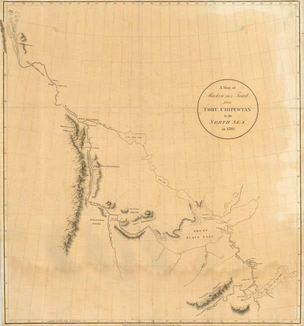
Alexander Mackenzie was the first white man to cross the North American continent north of Mexico and thus totally dispel the belief in a Northwest Passagefrom Hudson Bay. His epic journey was one of incredible hardship and marks an important page in the cartographic history of North America. This map is from his first journey in search of the passage in 1789. Mackenzie went on an expedition to chart the 1,100-mile Mackenzie River, traveling from the Great Slave Lake to Mackenzie Bay in the Arctic Ocean. He had been following Peter Pond's false prediction of a river that led from the Great Slave Lake west to the Pacific Ocean, but instead ended up in the Arctic. Mackenzie was eventually successful in finding the Pacific in 1793 via smaller river systems and overland travel to Bella Coola in British Columbia. Mackenzie retired back to his native Scotland as a wealthy fur-trader, where he wrote Voyage from Montreal on the River St. Lawrence, Through the Continent of North America, to the Frozen and Pacific Oceans, in the Years 1789 and 1793, which he published in London in 1801. A scarce map of the exploration of North America and the Arctic.
References: Wagner-Camp #1:1; Wheat (TMW) #251.
Condition: B
Linen-backed with some damp stain in the bottom and some light foxing with uneven toning throughout. Still a nice example of a hard to find map.