Subject: World & Continents
Period: 1740 (circa)
Publication:
Color: Hand Color
This gorgeous, matched set of maps was produced by one of the most important German cartographers of the 18th century. While this era saw the production of more technical and scientific maps, this set is an example of combining the scientific and the lushly decorative together.
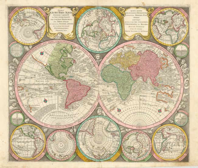
1) Diversi Globi Terr-Aquei is one of the most graphic 18th century world maps. The bold engraving style follows Carel Allard's map of 1696 with the central twin hemisphere map surrounded by several smaller maps on various projections. California is an island on the Sanson model with a flat, indented northern coast, and it is shown five times on the sheet. In Asia, Japan is shown in a bizarre shape that incorporates the fictional Terra Yedso, and only a portion of Australia and New Zealand are shown in the Pacific. The map is filled with detail including the tracks of Tasman, Dampier and more. The hemispheres and a plethora of smaller globes are set in a richly engraved background of clouds with numerous wind heads and two cartouches. (22.4 x 19.5)
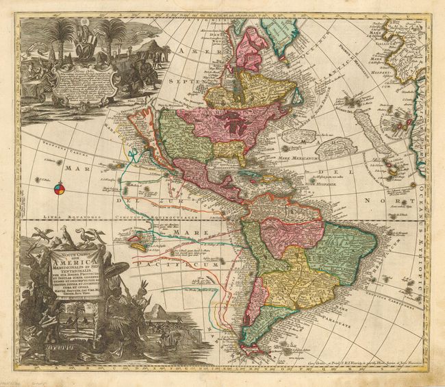
2) Novus Orbis sive America Meridionalis et Septentrionalis... is a splendid map of the Americas with an insular California. Directly above the island is the strait Fretum Anian with the coastline of Terra Isonis incogn, that is obscured by an elaborate pictorial cartouche relating to the religious conversion of the natives. The map is filled with place names and details the tracks of the major voyages of exploration in the Pacific. An odd Fl. Mortis, with three lake chains nearly connects the Mississippi with the Pacific. The large title cartouche depicts Native Americans fishing, cutting sugar cane, farming, and paying tribute to a chief. This appears to be an interim state, between 2 and 3, when compared to McLaughlin's list. The map matches state 2 with the exception that the credit has been added at lower right. (22.3 x 19.25)
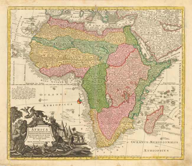
3) Africa Juxta Navigationes et Observationes Recentissimas... is a striking map of Africa based largely on Homann's 1715 map. Seutter was apprenticed to Homann prior to establishing his own publishing business in the early 18th century. The map is typical of the period with the information in southern Africa being largely fictitious with enormous lakes depicted in central Africa. The Nile is shown originating in the south from lakes Zaire and Zaflan. The Abyssinian province of Amhara is incorrectly shown in the southern kingdom of Monomotapa. The splendid decorative cartouche features natives, pyramids and exotic animals with the title surmounted by a fierce dragon. (22.25 x 19.25)
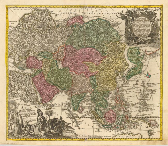
4) Asia cum Omnibus Imperiis Provinciis, Statibus et Insulis… is a beautifully engraved and extremely detailed map that covers the Asian continent and the East Indies. Terra Yedso is represented here as a large landmass linked to Japan by a narrow causeway. Compagnie Land is shown to the east and marked with a notation that it was discovered by Don Juan de Gama. There is no Kamchatka peninsula shown. One of the more interesting features is the representation of Nova Zembla which, in contrast to most contemporary maps, is shown as a peninsula joined to the mainland. The large and charming title cartouche represents the exotic East with its people and animals. Another large and decorative cartouche at top right also features its peoples with several exotic birds. (22.4 x 19.25)
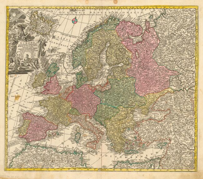
5) Europa Religionis Christianae... is a lovely, decorative map of Europe drawn to glorify Christianity. The title claims that Christian Europe is most accomplished in the ways of peace, war and the cultivation of the arts. The imagery in the cartouche shows cherubs descending from the Godhead with the symbols of Catholicism, and the queen, Europa, representing good government, and Athena and Apollo representing war and the arts. (22.5 x 19.4)
References: 2) McLaughlin #211; Tooley (America) #91, plt. 61. Map 3-Norwich 80. Map 4-Yeo #120.
Condition: B
All maps generally good with minor soiling, primarily finger soil. Europe with a couple stains. Original outline color.